Nevada
Descripción
Nevada is a sparsely populated state in the West of the country.
The Tahoe Rim Trail, 165 miles, is shared with California in the West. The American Discovery Trail crosses Nevada.
The wilderness and emptiness of Nevada – high mountain ranges, desert brushlands, canyons - is best enjoyed on the thousands of miles of trails in the Toyabe National Forest, Humboldt National Forest and Great Basin National Park.
Mapa

Senderos en estado
Enlaces
Datos
Informes
Guías y mapas
Hospedaje
Organizaciones
Operadores turísticos
GPS
Otro
Libros

Stanfords
United Kingdom
United Kingdom
- Waldviertel North - Gmund - Heidenreichstein - Waidhofen & Raabs a.d.T. - Trebon F&B WK075
- Waldviertel North - Gmünd - Heidenreichstein - Waidhofen a.d.T. - Raabs a.d.T. – Trebon area of eastern Austria presented at 1:50,000 in a series of contoured and GPS compatible outdoor leisure map from Freytag & Berndt with hiking and cycling routes, mountain huts, campsites and youth hostels, local bus stops, plus other tourist information.To... Leer más

Stanfords
United Kingdom
United Kingdom
- Lake Mead National Recreation Area NV/AZ
- Map No. 204, Lake Mead National Recreation Area on the borderof Arizona and Nevada, at 1:166,800 in an extensive series of GPS compatible, contoured hiking maps of USA’s national and state parks or forests and other popular recreational areas. Cartography based on the national topographic survey, with additional tourist information.The maps,... Leer más

The Book Depository
United Kingdom
United Kingdom
- Hiking the Sierra Nevada
- A Guide to the Area's Greatest Hiking Adventures Leer más


The Book Depository
United Kingdom
United Kingdom
- Five-Star Trails: Lake Tahoe
- 40 Unforgettable Hikes in the Central Sierra Nevada Leer más


The Book Depository
United Kingdom
United Kingdom
- Backpacking Nevada
- From Slickrock Canyons to Granite Summits Leer más


The Book Depository
United Kingdom
United Kingdom
- Tahoe Rim Trail
- The Official Guide for Hikers, Mountain Bikers, and Equestrians Leer más

- Also available from:
- De Zwerver, Netherlands


The Book Depository
United Kingdom
United Kingdom
- Sierra North
- Backcountry Trips in California's Sierra Nevada Leer más


The Book Depository
United Kingdom
United Kingdom
- Afoot & Afield: Las Vegas & Southern Nevada
- A Comprehensive Hiking Guide Leer más

The Book Depository
United Kingdom
United Kingdom
- Sierra South
- Backcountry Trips in California's Sierra Nevada Leer más
The Book Depository
United Kingdom
United Kingdom
Mapas

Stanfords
United Kingdom
United Kingdom
- Nevada Road & Recreation Atlas
- Nevada at 1:280,000 in a series of excellent, detailed, GPS compatible state atlases from Benchmark Maps with extensive information on diverse recreational opportunities and facilities, covering The Rockies and the western states of the United States. Each atlas consists of three main sections:*Landscape:* with detailed mapping at scales around... Leer más

Stanfords
United Kingdom
United Kingdom
- Landscapes along the River Ter Ed. Alpina 40K Map
- Landscapes along the River Ter map in an extensive and very popular series of walking maps from Editorial Alpina covering the Pyrenees, Catalonia and other selected hiking areas in Spain, including Picos de Europa, Sierra Nevada and parts of Andalucía, Majorca, etc. Scales vary from 1:50,000 to 1:10,000, with the majority of the titles at... Leer más

Stanfords
United Kingdom
United Kingdom
- Valles de Belagua y Roncal Editorial Alpina
- Valles de Belagua & Roncal in an extensive and very popular series of walking maps from Editorial Alpina covering the Pyrenees, Catalonia and other selected hiking areas in Spain, including Picos de Europa, Sierra Nevada and parts of Andalucía, Majorca, etc. Scales vary from 1:50,000 to 1:10,000, with the majority of the titles at 1:25,000. The... Leer más

Stanfords
United Kingdom
United Kingdom
- Val d`Aran by UTMB Editorial Alpina Trail running race Map
- Val d`Aran in an extensive and very popular series of walking maps from Editorial Alpina covering the Pyrenees, Catalonia and other selected hiking areas in Spain, including Picos de Europa, Sierra Nevada and parts of Andalucía, Majorca, etc. Scales vary from 1:50,000 to 1:10,000, with the majority of the titles at 1:25,000. The maps have... Leer más
Stanfords
United Kingdom
United Kingdom
- Bachimala - Valles de Chistau y Bielsa Editorial Alpina
- Bachimala area of the High Pyrenees in Spain on a contoured and GPS compatible map at 1:25,000 from Editorial Alpina, with a booklet including English language descriptions of recommended walks, extensive accommodation list, etc. With the peak of Gran Bachimala towards the north-eastern corner of the map, coverage extends west to Bielsa and... Leer más

Stanfords
United Kingdom
United Kingdom
- Vall de Barravés - Ribagorça Editorial Alpina
- Val de Barravés - Ribagorça at 1:25,000 in an extensive and very popular series of walking maps from Editorial Alpina covering the Pyrenees, Catalonia and other selected hiking areas in Spain, including Picos de Europa, Sierra Nevada and parts of Andalucía, Majorca, etc.Scales of maps in this series vary from 1:50,000 to 1:10,000, with the... Leer más

Stanfords
United Kingdom
United Kingdom
- Sierra Nevada - the Traverse at 3000m Editorial Piolet Hiking Map
- Sierra Nevada: The Traverse at 3000m Altitude map at 1:25,000 in a series of GPS compatible maps from Editorial Piolet with cartography based on Spain’s civilian topographic survey overprinted with hiking routes and other tourist information. The map highlights the course of “La Integral de los 3000” route across the highest part of the Sierra... Leer más

Stanfords
United Kingdom
United Kingdom
- GR 240: Tour of the Sierra Nevada (Sendero Sulayr)
- A tour around the Sierra Nevada presented in an English language guide from Editorial Penibética, with contoured mapping at 1:40,000, detailed descriptions of each stage, route profiles, numerous colour photographs, etc.The guide divides the route into 19 stages of between 2h 30’ and 7h 30’, covering it in an anti-clockwise direction starting... Leer más

Stanfords
United Kingdom
United Kingdom
- Las Vegas Borch
- Very clear, indexed tourist street plan of the city on durable, laminated paper, with additional maps of the surrounding area and the Grand Canyon. The main map includes the Strip, Interstate 15 to the west, Downtown, the international airport, and much of the Winchester district east of the Strip. Detail includes one-way streets, casinos,... Leer más
Stanfords
United Kingdom
United Kingdom
- Sant Llorenc del Munt i l`Obac Editorial Alpina
- Sant Llorenç del Munt i l`Obac area at 1:25,000 in an extensive and very popular series of walking maps from Editorial Alpina. Contours are at 10m intervals, enhanced by relief shading and vegetation colouring. The map has UTM grid and 1’ margin ticks. In addition to footpaths, the overprint shows various types of accommodation (hotels,... Leer más

Stanfords
United Kingdom
United Kingdom
- Sierra Nevada - Las Alpujarras CNIG Map
- Sierra Nevada Mountain, southern Spain’s most popular national park, on GPS compatible map at 1:100,000 from IGN/CNIG with cartography based on their civilian topographic survey of Spain, plus a panorama drawing of the mountains as seen from the coast. The map covers a large area, extending from Granada in the west to beyond Gérgal in the east,... Leer más

Stanfords
United Kingdom
United Kingdom
- Andalusia Autonomous Community CNIG Physical Road Map
- Andalucía Autonomous Region of Spain at 1:400,000 on a large physical map from the IGN/CNIG - country’s civilian survey organization providing an excellent picture of the region’s topography, from the peaks of Sierra Nevada to the marshes of the Doñana National Park.Relief shading is enhanced by bright altitude colouring, with plenty of names... Leer más

Stanfords
United Kingdom
United Kingdom
- Andalucía East: Granada - Almería - Murcia 500K CNIG Regional Map No. 12
- The eastern part of Andalucía with Granada and Sierra Nevada, extending along the Mediterranean coast from Velez-Malága to Cartagena and Mar Menor, at 1:500,000 in a series of regional road maps from the country’s civilian survey organization IGN-CNIG (Instituto Geográfico Nacional - Centro Nacional de Información Geográfica), vividly... Leer más

Stanfords
United Kingdom
United Kingdom
- Muntanya d’Alinyà Editorial Alpina
- Muntanya d’Alinyà, including Serra d’Aubenç and Serra de Turp, in an extensive and very popular series of walking maps from Editorial Alpina covering the Pyrenees, Catalonia and other selected hiking areas in Spain, including Picos de Europa, Sierra Nevada and parts of Andalucía, Majorca, etc. Scales vary from 1:50,000 to 1:10,000, with the... Leer más
Stanfords
United Kingdom
United Kingdom
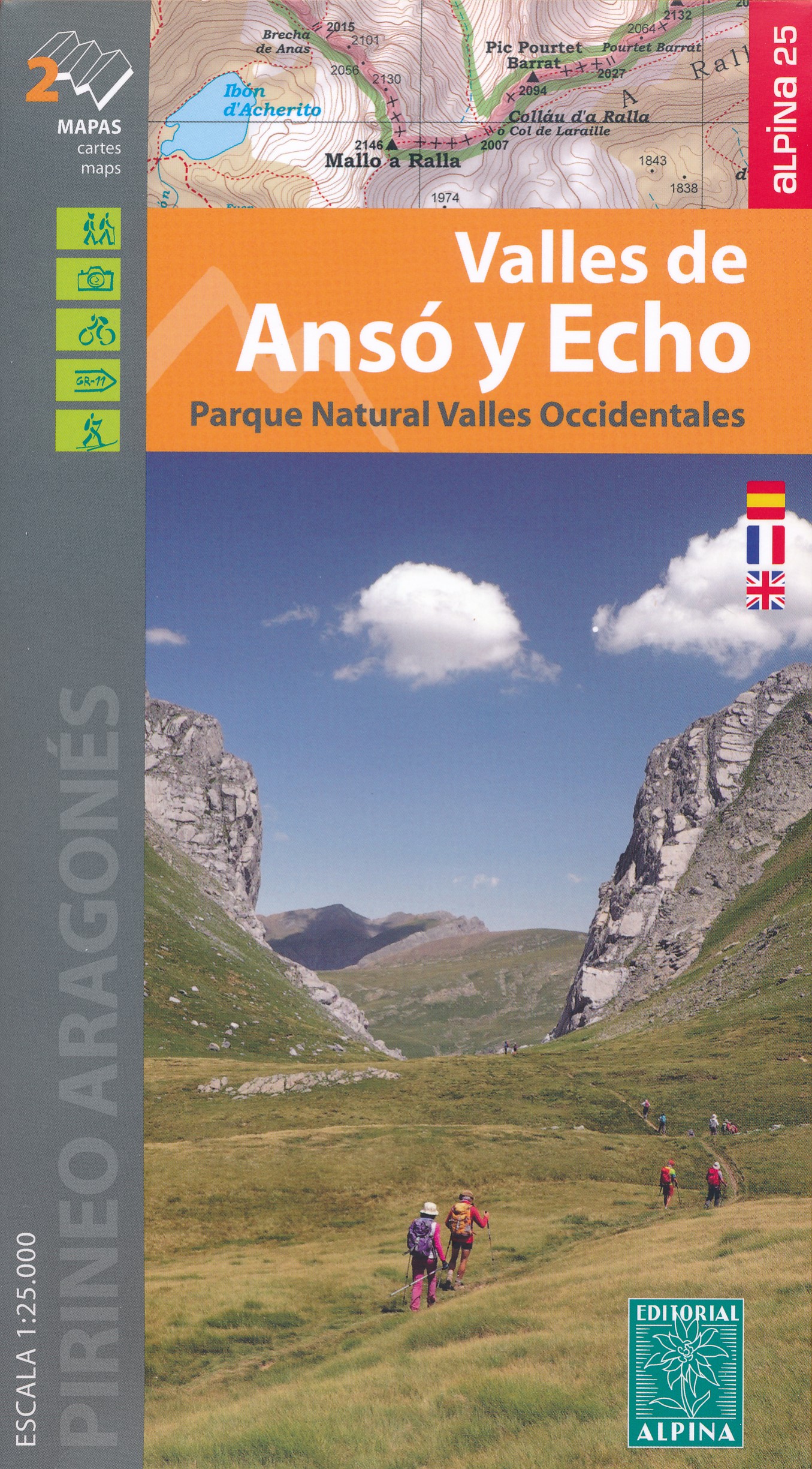
- Valles de Ansó & Echo Editorial Alpina
- Valles de Ansó & Echo in an extensive and very popular series of walking maps from Editorial Alpina covering the Pyrenees, Catalonia and other selected hiking areas in Spain, including Picos de Europa, Sierra Nevada and parts of Andalucía, Majorca, etc. Scales vary from 1:50,000 to 1:10,000, with the majority of the titles at 1:25,000. The maps... Leer más
- Also available from:
- The Book Depository, United Kingdom
- De Zwerver, Netherlands