
British Columbia
Descripción
Mapa

Senderos en estado
Enlaces
Datos
Informes
Guías y mapas
Hospedaje
Organizaciones
Operadores turísticos
GPS
Otro
Libros

Stanfords
United Kingdom
United Kingdom
- DK Eyewitness Canada
- Vast, vibrant and breathtakingly beautiful - welcome to Canada.Whether you want to hike along exhilarating trails beneath snowy peaks, paddle a canoe on backcountry rivers or head to the Arctic for the greatest light show on earth, your DK Eyewitness travel guide makes sure you experience all that Canada has to offer.Unimaginably large,... Leer más

Stanfords
United Kingdom
2019
United Kingdom
2019
- Insight Guides Explore Vancouver & Victoria (Travel Guide with Free eBook)
- Focused travel guide featuring the very best routes and itineraries, now with free eBook.Discover the best of Vancouver and Victoria with this unique travel guide, packed full of insider information and stunning images. From making sure you don`t miss out on must-see, top attractions like Stanley Park, Capilano Suspension Bridge and Granville... Leer más

Stanfords
United Kingdom
2020
United Kingdom
2020
- DK Eyewitness Pacific Northwest: Oregon, Washington and British Columbia
- Follow the call of the wild to the pristine Pacific NorthwestWhether you want to hike through the spellbinding landscape of the Rockies, unwind with homebrewed beer in Portland or venture to Vancouver for immersive galleries and innovative dining, your DK Eyewitness travel guide makes sure you experience all that the Pacific Northwest has to... Leer más

Stanfords
United Kingdom
United Kingdom
- Kootenay National Park Gem Trek Map
- Kootenay National Park in the Canadian Rockies at 1:100,000 on a contoured and GPS compatible, waterproof and tear-resistant map from Gem Trek Publishing, highlighting hiking trails, recreational areas, accommodation options, etc, plus on the reverse extensive tourist information including descriptions of recommended routes.The map provides a... Leer más

Stanfords
United Kingdom
United Kingdom
- DK Eyewitness Travel Guide Canada
- DK Eyewitness travel guides: award-winning guidebooksDiscover Canada with this essential travel guide, designed to help you create your own unique trip and to transport you to this incredible country before you`ve even packed your case - marvel at the magnificent thundering waterfalls of Niagara Falls, hike through spectacular scenery in Banff... Leer más

The Book Depository
United Kingdom
United Kingdom
- The Best of The Great Trail
- British Columbia to Northern Ontario on the Trans Canada Trail Leer más


The Book Depository
United Kingdom
United Kingdom
- Beer Hiking Pacific Northwest
- The Most Refreshing Way to Discover Washington, Oregon and British Columbia Leer más

The Book Depository
United Kingdom
2018
United Kingdom
2018
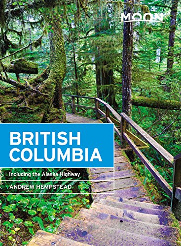
- Moon British Columbia (Eleventh Edition)
- Including the Alaska Highway Leer más
- Also available from:
- De Zwerver, Netherlands
De Zwerver
Netherlands
2018
Netherlands
2018
- Reisgids British Columbia | Moon Travel Guides
- Including the Alaska Highway Leer más


The Book Depository
United Kingdom
United Kingdom
- Hiking Trails of the Pacific Northwest
- Northern California, Oregon, Washington, Southwestern British Columbia Leer más
Mapas

Stanfords
United Kingdom
United Kingdom
- Vancouver Island - Sunshine Coast - Gulf Islands BC MapArt
- Vancouver Island with the Sunshine Coast of mainland British Columbia plus the Gulf presented at 1:550,000 on an indexed road map presenting accompanied by numerous enlargements and street maps of the region’s most visited locations.On one side is the main indexed road map showing Vancouver Island with the adjoining mainland BC and the Gulf... Leer más

Stanfords
United Kingdom
United Kingdom
- Garibaldi Provincial Park ITMB
- Garibaldi Provincial Park at 1:50,000 in a series of topographic survey maps of selected areas of British Columbia and the Canadian Rockies from ITMB with cartography from Canada’s national survey organization. Most sheets are printed on light, waterproof and tear- resistant plastic paper.Whilst the Canadian Department of Natural Resources... Leer más

Stanfords
United Kingdom
United Kingdom
- Fraser Valley and Vancouver ITMB
- Double-sided map from ITMB combining coverage of the south-western tip of British Columbia at 1:250,000 with a more detailed road map of the Vancouver conurbation. On one side is a road map covering the area from Vancouver northwards to Whistler and eastwards beyond the Fraser Valley to Princeton. The map has altitude colouring with spot... Leer más

Stanfords
United Kingdom
United Kingdom
- Okanagan Communities - Kelowna BC
- Double-sided, indexed street plan at 1:30,000 of towns in the Okanagan Region of British Columbia, including Kelowna, Penticton, Vernon, Coldstream, Enderby, Lake County, Okanagan Falls, Oliver, Armstron, Osoyoos, Peachland and Summerland. Also provided is a small road map of the region with coverage including Hope, Kamloops and... Leer más

Stanfords
United Kingdom
United Kingdom
- North Vancouver - Port Coquitlam ITMB
- North Vancouver - Port Coquitlam at 1:50,000 in a series of topographic survey maps of selected areas of British Columbia and the Canadian Rockies from ITMB with cartography from Canada’s national survey organization. Most sheets are printed on light, waterproof and tear- resistant plastic paper.Whilst the Canadian Department of Natural... Leer más

Stanfords
United Kingdom
United Kingdom
- British Columbia ITMB Pocket Road Atlas
- 75-page, A5 paperback atlas of British Columbia from the Vancouver based ITMB, with street plans of central Vancouver, Victoria and Whistler Village, plus enlargements for the southern tip of the Vancouver Island, the environs of Vancouver and the recreational area around Whistler.The southern half of the province, including most of the Queen... Leer más
Stanfords
United Kingdom
United Kingdom
- Revelstoke National Park ITMB
- Revelstoke National Park at 1:50,000 in a series of topographic survey maps of selected areas of British Columbia and the Canadian Rockies from ITMB with cartography from Canada’s national survey organization. Most sheets are printed on light, waterproof and tear- resistant plastic paper.Whilst the Canadian Department of Natural Resources... Leer más

Stanfords
United Kingdom
United Kingdom
- British Columbia - Alberta MapArt
- British Columbia and Alberta, including the Banff and Jasper National Parks, on an indexed, double-sided road map presenting both provinces together at 1:2,000,000, plus more detailed mapping of the region’s main urban areas including Vancouver, Victoria, Calgary, etc.On one side both provinces are shown together at 1:2m with their road network... Leer más

Stanfords
United Kingdom
United Kingdom
- Jasper & Maligne Lake Gem Trek
- Jasper - Maligne Lake area of the Jasper National Park at 1:100,000 on a GPS compatible, waterproof and tear-resistant map from Gem Trek, with very extensive tourist information including recommendations for day or longer hikes, mountain biking trails, notes on camping permits, more detailed enlargements, etc.The map covers the most popular... Leer más

Stanfords
United Kingdom
United Kingdom
- Bowron Lakes Canoe Route ITMB
- Bowron Lakes Canoe Route at 1:50,000 in a series of topographic survey maps of selected areas of British Columbia and the Canadian Rockies from ITMB with cartography from Canada’s national survey organization. Most sheets are printed on light, waterproof and tear- resistant plastic paper.Whilst the Canadian Department of Natural Resources... Leer más

Stanfords
United Kingdom
United Kingdom
- Vancouver FastTrack
- Vancouver’s on a double-sided, waterproof and tear-resistant, indexed street plan showing on one side the city at 1:28,000, with coverage including Burnaby and the Lower Lonsdale district of North Vancouver. On the reverse separate panels show downtown Vancouver in greater detail at 1:19,000, the University of British Columbia Campus and access... Leer más

Stanfords
United Kingdom
United Kingdom
- Alberta & Saskatchewan
- Alberta, including the Banff and Jasper National Parks, and Saskatchewan on an indexed road map presenting both provinces at 1:1,850,000, each accompanied by several street maps of their main cities, including detailed plans of downtown Calgary, Edmonton, Regina and Saskatoon.On one side is a road map of Alberta with coverage extending within... Leer más

Stanfords
United Kingdom
United Kingdom
- Banff - Egypt Lake Gem Trek
- Banff - Egypt Lake, a contoured and GPS compatible map at 1:50,000 from Gem Trek of the main hiking area in the Banff National Park, with coverage around Banff itself, including trails eastwards to Lake Minnewanka and Johnson, and extending westwards across the state border to include parts of Kootenay NP and Mt. Assiniboine Provincial Park.... Leer más

Stanfords
United Kingdom
United Kingdom
- British Columbia FastTrack
- British Columbia, with coverage extending to Calgary to include the Banff and Jasper National Parks, on an indexed, waterproof and tear-resistant, handy size FastTrack map, presenting the whole province on two overlapping panels at 1:2,000,000, with more detailed enlargements and street plans covering the Vancouver at 1:1,275,000, the Victoria... Leer más

Stanfords
United Kingdom
United Kingdom
- Vancouver Island FastTrack
- Waterproof and tear-resistant FastTrack map presenting in a handy-size format Vancouver Island at 1:550,000, plus a street plan of downtown Victoria and on the reverse enlargements at 1;50,000 covering the island’s other most visited areas.On one side Vancouver Island is shown at 1:550,000, with its northern part presented on a separate panel.... Leer más