
Peak District
Descripción
Beloved region in Central England. The Peak District - wild hills and friendly valleys - attracts many walkers from the nearby population centres and beyond. Best known trail is the Pennine Way. The Peak District in fact marks the southern end of the Pennines.
Senderos en región
Enlaces
Datos
Informes
Guías y mapas
Hospedaje
Organizaciones
Operadores turísticos
GPS
Otro
Libros

Stanfords
United Kingdom
United Kingdom
- Peak District - Teashop Walks
- 20 circular walks based on good local teashops. Leer más

Stanfords
United Kingdom
United Kingdom
- Railway Walks: LMS
- Jeff Vinter, consultant to the BBC`s popular ”Railway Walks” series, here provides a detailed guide to ten of the best railway walks in the territory of the former London Midland and Scottish Railway. These range from the Midland Railway`s express line through the Peak District to the incredible Cromford and High Peak Railway, built before... Leer más

Stanfords
United Kingdom
United Kingdom
- The Peak District - Kiddiwalks
- Here is a book of twenty safe walks devised with active children in mind. Packed with fun things to see and do, each circular route offers a great outing. Leer más

Stanfords
United Kingdom
United Kingdom
- Wild Pub Walks
- Join the author on 30 walks in beautiful remote or mountain landscapes, each with a great pub - often with historical significance - at journey`s end. The book is aimed at the large market of hill walkers who enjoy long days out followed by a great pint in a great pub.The areas covered are: Peak District; Lake District; Highlands/Islands;... Leer más

Stanfords
United Kingdom
United Kingdom
- 100 Walks in Staffordshire
- Staffordshire offers a wide range of delights for the walker - from the windswept Peak District through riverside walks to picturesque villages. This collection of 100 walks ranges from between three to eleven miles in length, with routes to suit all walking abilities. Full-colour mapping is included which is sourced from the Ordnance Survey. Leer más

Stanfords
United Kingdom
2015
United Kingdom
2015
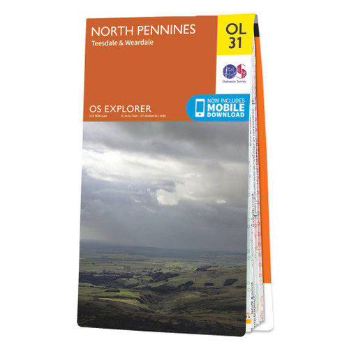
- North Pennines: Teesdale & Weardale OS Explorer Map OL31 (paper)
- The northern part of the Pennines including Teesdale and Weardale on a detailed topographic and GPS compatible map OL31, paper version, from the Ordnance Survey’s 1:25,000 Explorer series. Coverage include Barnard Castle, Middleton-in-Teesdale, Stanhope, Blagill, Gilderdale Forest, Milburn Forest, Hamsterley Forest, Middleton Common, the peaks... Leer más
- Also available from:
- De Zwerver, Netherlands

Stanfords
United Kingdom
United Kingdom
- Stratford-upon-Avon, Warwick & Banbury OS Landranger Active Map 151 (waterproof)
- The area between Stratford-upon-Avon, Warwick and Banbury, including the northern part of the Cotswold Hills and part of the Cotswold Way / E2 European Long-distance Path, on a waterproof and tear-resistant OS Active version of map No. 151 from the Ordnance Survey’s Landranger series at 1:50,000, with contoured and GPS compatible topographic... Leer más

Stanfords
United Kingdom
United Kingdom
- Cambridge, Newmarket & Saffron Walden OS Landranger Active Map 154 (waterproof)
- Parts of Cambridgeshire, Suffolk and Essex with Cambridge, Newmarket and Saffron Walden, including part of the E2 European Long-distance path, on a waterproof and tear-resistant OS Active version of map No. 154 from the Ordnance Survey’s Landranger series at 1:50,000, with contoured and GPS compatible topographic mapping plus tourist... Leer más

Stanfords
United Kingdom
2015
United Kingdom
2015
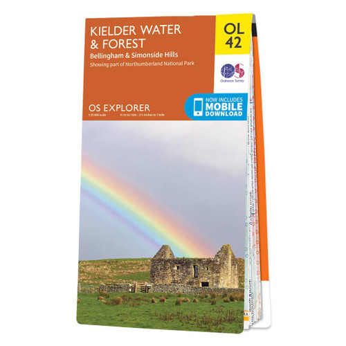
- Kielder Water & Forest - Bellingham & Simonside Hills OS Explorer Map OL42 (paper)
- Kielder Water and Kielder Forest on a detailed topographic and GPS compatible map OL42, paper version, from the Ordnance Survey’s 1:25,000 Explorer series. Coverage includes Simonside Hills, Kershope Forest, Liddesdale, Sweethope Loughs, the peaks of The Dodd, Muckle Knowe, Mid Fell, the lakeside circuit around the Kielder Water, a section of... Leer más
- Also available from:
- De Zwerver, Netherlands

Stanfords
United Kingdom
United Kingdom
- Bury St Edmunds, Sudbury & Stowmarket OS Landranger Active Map 155 (waterproof)
- Suffolk around Bury St Edmunds, Sudbury and Stowmarket, including part of the E2 European Long-distance path, on a waterproof and tear-resistant OS Active version of map No. 155 from the Ordnance Survey’s Landranger series at 1:50,000, with contoured and GPS compatible topographic mapping plus tourist information.MOBILE DOWNLOADS: As well as... Leer más

Stanfords
United Kingdom
United Kingdom
- Birmingham, Wolverhampton & The Black Country OS Landranger Map 139 (paper)
- Birmingham with the surrounding area including the Black Country, Wolverhampton, Walsall, Solihull, Stourbridge, Bromsgrove and a section of the E2 European Long-distance Path on a paper version of map No. 139 from the Ordnance Survey’s Landranger series at 1:50,000, with contoured and GPS compatible topographic mapping plus tourist... Leer más
- Also available from:
- De Zwerver, Netherlands


Stanfords
United Kingdom
United Kingdom
- Peak District Mountain Biking
- Vertebrate’s guide to mountain biking in the Peak District covers6 of the best mountain bike rides in the Dark Peak, between 11.5km and 105km in length, suitable for all levels of mountain bikers.Each route is described with easy-to-follow instructions, information on difficulty, length, nearest refreshments (usually a recommended pub),... Leer más

Stanfords
United Kingdom
United Kingdom
- Maidstone, Royal Tunbridge Wells, Sevenoaks & Tonbridge OS Landranger Active Map 188 (waterproof)
- Maidstone, Tunbridge Wells and the High Weald area, including a section of the North Downs Way / E2 European Long-distance Path, on a waterproof and tear-resistant OS Active version of map No. 188 from the Ordnance Survey’s Landranger series at 1:50,000, with contoured and GPS compatible topographic mapping plus tourist information.MOBILE... Leer más

Stanfords
United Kingdom
United Kingdom
- Kettering, Corby, Market Harborough & Stamford OS Landranger Map 141 (paper)
- The area around Kettering, Corby, Market Harborough and Stamford, including Rockingham Forest and part of the E2 European Long-distance Path, on a paper version of map No. 141 from the Ordnance Survey’s Landranger series at 1:50,000, with contoured and GPS compatible topographic mapping plus tourist information.MOBILE DOWNLOADS: As well as the... Leer más
- Also available from:
- De Zwerver, Netherlands


Stanfords
United Kingdom
United Kingdom
- North York Moors Western OS Explorer Active Map OL26 (waterproof)
- The western part of the North York Moors National Park on a detailed topographic and GPS compatible map OL26, waterproof version, from the Ordnance Survey’s 1:25,000 Explorer series. Coverage extends from Ampleforth in the south northwards to Saltburn-by-the-Sea, and from Ingleby Arncliffe to Danby, Castleton and Hutton-le-Hole, and includes... Leer más
Mapas
Stanfords
United Kingdom
United Kingdom
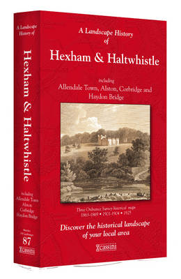
- Hexham and Haltwhistle 1863-1925 (3-map set)
- Map No. 87, Hexham and Haltwhistle 1983-1925 (3-map set), in the Cassini Historical Series of old Ordnance Survey mapping of England and Wales at 1:50,000 in a format designed to offer a convenient comparison with the present day coverage from the OS, and most locations in three different editions. Old historical maps have been combined so that... Leer más

Stanfords
United Kingdom
United Kingdom
- Manchester 1903
- Map No. 109, Manchester 1903, in the Cassini Historical Series of old Ordnance Survey mapping of England and Wales at 1:50,000 in a format designed to offer a convenient comparison with the present day coverage from the OS, and most locations in three different editions. Old historical maps have been combined so that the sheet lines correspond... Leer más

Stanfords
United Kingdom
United Kingdom
- Pennine Way North A-Z Adventure Atlas
- The Pennine Way North Adventure Atlas, presenting the northern section of the route between Kirk Yetholm in the Cheviot Hills and Bowes near Barnard Castle on mapping at 1:25,000 in a series of handy A5 size Adventure Atlases from Geographers` A-Z Map Company with cartography from the Ordnance Survey’s Explorer series. Coverage includes a large... Leer más
Stanfords
United Kingdom
United Kingdom
- Cheviot Hills and Kielder Water 1868-1869
- Map No. 80, Cheviot Hills and Kielder Water 1868-1869, in the Cassini Historical Series of old Ordnance Survey mapping of England and Wales at 1:50,000 in a format designed to offer a convenient comparison with the present day coverage from the OS, and most locations in three different editions. Old historical maps have been combined so that... Leer más

Stanfords
United Kingdom
United Kingdom
- Pennine Bridleway: From Derbyshire through the Yorkshire Dales to Cumbria
- Pennine Bridleway is a guidebook to this National Trail taking you from Derbyshire through the Yorkshire Dales to Cumbria, following the Pennine Hills.The route is split into four sections; each section includes detailed directions as well as information on points of interest along the route, bringing the history and landscape of the trail into... Leer más
Stanfords
United Kingdom
United Kingdom
- Cheviot Hills and Kielder Water 1925-1926
- Map No. 80, Cheviot Hills and Kielder Water 1925-1926, in the Cassini Historical Series of old Ordnance Survey mapping of England and Wales at 1:50,000 in a format designed to offer a convenient comparison with the present day coverage from the OS, and most locations in three different editions. Old historical maps have been combined so that... Leer más
Stanfords
United Kingdom
United Kingdom
- Cheviot Hills and Kielder Water 1901
- Map No. 80, Cheviot Hills and Kielder Water 1901, in the Cassini Historical Series of old Ordnance Survey mapping of England and Wales at 1:50,000 in a format designed to offer a convenient comparison with the present day coverage from the OS, and most locations in three different editions. Old historical maps have been combined so that the... Leer más
Stanfords
United Kingdom
United Kingdom
- Manchester 1842-1844
- Map No. 109, Manchester 1842-1844, in the Cassini Historical Series of old Ordnance Survey mapping of England and Wales at 1:50,000 in a format designed to offer a convenient comparison with the present day coverage from the OS, and most locations in three different editions. Old historical maps have been combined so that the sheet lines... Leer más
Stanfords
United Kingdom
United Kingdom
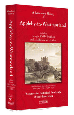
- Appleby-in-Westmorland 1860-1925 (3-map set)
- Map No. 91, Appleby-in-Westmorland 1860-1925 (3-map set), in the Cassini Historical Series of old Ordnance Survey mapping of England and Wales at 1:50,000 in a format designed to offer a convenient comparison with the present day coverage from the OS, and most locations in three different editions. Old historical maps have been combined so that... Leer más
Stanfords
United Kingdom
United Kingdom
- Sheffield and Huddersfield 1903
- Map No. 110, Sheffield and Huddersfield 1903, in the Cassini Historical Series of old Ordnance Survey mapping of England and Wales at 1:50,000 in a format designed to offer a convenient comparison with the present day coverage from the OS, and most locations in three different editions. Old historical maps have been combined so that the sheet... Leer más

Stanfords
United Kingdom
United Kingdom
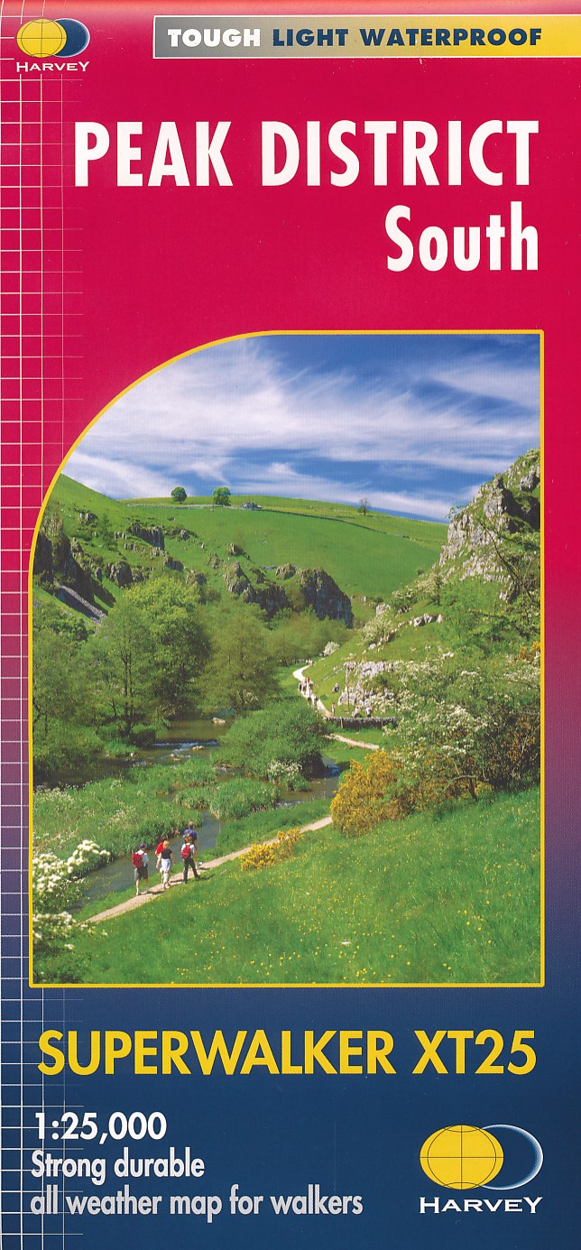
- Peak District South Harvey Superwalker XT25
- The southern part of the Peak District at 1:25,000 on a light, waterproof and tear-resistant map from Harvey Map Services in their Superwalker series. Coverage extends southwards from the outskirts of Buxton and west/east between Leek and Matlock.PLEASE NOTE: this title is also available as a pocket-size Ultramap with its scale reduced to... Leer más
- Also available from:
- De Zwerver, Netherlands
De Zwerver
Netherlands
Netherlands
- Wandelkaart Peak District South | Harvey Maps
- The southern part of the Peak District at 1:25,000 on a light, waterproof and tear-resistant, GPS compatible, double-sided map from Harvey Map Services in their Superwalker series. Coverage extends southwards from the outskirts of Buxton and west/east between Leek and Matlock. The whole of Peak District is covered on three Superwalker maps Leer más
Stanfords
United Kingdom
United Kingdom
- Haltwhistle and Brampton 1866-1869
- Map No. 86, Haltwhistle and Brampton 1866-1869, in the Cassini Historical Series of old Ordnance Survey mapping of England and Wales at 1:50,000 in a format designed to offer a convenient comparison with the present day coverage from the OS, and most locations in three different editions. Old historical maps have been combined so that the sheet... Leer más
Stanfords
United Kingdom
United Kingdom
- Haltwhistle and Brampton 1925
- Map No. 86, Haltwhistle and Brampton 1925, in the Cassini Historical Series of old Ordnance Survey mapping of England and Wales at 1:50,000 in a format designed to offer a convenient comparison with the present day coverage from the OS, and most locations in three different editions. Old historical maps have been combined so that the sheet... Leer más
Stanfords
United Kingdom
United Kingdom
- Haltwhistle and Brampton 1901-1904
- Map No. 86, Haltwhistle and Brampton 1901-1904, in the Cassini Historical Series of old Ordnance Survey mapping of England and Wales at 1:50,000 in a format designed to offer a convenient comparison with the present day coverage from the OS, and most locations in three different editions. Old historical maps have been combined so that the sheet... Leer más
Stanfords
United Kingdom
United Kingdom
- Sheffield and Huddersfield 1840-1841
- Map No. 110, Sheffield and Huddersfield 1840-1841, in the Cassini Historical Series of old Ordnance Survey mapping of England and Wales at 1:50,000 in a format designed to offer a convenient comparison with the present day coverage from the OS, and most locations in three different editions. Old historical maps have been combined so that the... Leer más