
Berchtesgadener Alpen
Descripción

The Berchtesgaden Alps is one of the highest areas in Germany. Around the pitturesque Königsee rise the bare jagged mountains, as pimples out of the green woods and meadows. Watzmann is the highest mountain here (2.713 m), just a little lower than the Zugspitze, but 100% German.
This part of the Northern Limestone Alps intrudes into Austrian territory, more or less like a bag. The area is not far from Salzburg. The Berchtesgadener Alps continue on the Austrian side of the border, and the highest summit here is the Hochkönig, 2.941 m.
One of the attractions is the Steinernes Meer, the stony sea, a barren plateau with rocks, rocks, rocks.
Yes, walking is excellent here. Not only because of the many (more than 40) huts. But also because of the variety of trails, from easy to very challenging. The geological origin of the mountains is karst, and this means lots of hard rock and ... klettersteige, if you like them. Bonus is the relative calmness on the Austrian side, since the masses are draw to the areas with the big names, further south.
Mapa


Senderos en región
Enlaces
Datos
Informes
Guías y mapas
Hospedaje
Organizaciones
Operadores turísticos
GPS
Otro
Libros

United Kingdom
2018
- Walking in the Bavarian Alps
- A comprehensive guidebook detailing walks in Germany`s Bavarian Alps. Lying along the German-Austrian border in a thin sliver of land roughly 300km long, this area contains some of the most spectacular walking and beautiful scenery that Germany has to offer. 70 graded walks explore mountain landscapes, wild mountain gorges and alpine meadows as... Leer más
- Also available from:
- The Book Depository, United Kingdom
- De Zwerver, Netherlands

United Kingdom
2018
- Walking in the Bavarian Alps
- 70 mountain walks and treks in southern Germany Leer más

Netherlands
2018
- Wandelgids Beieren - Walking in the Bavarian Alps | Cicerone
- Guidebook to mountain walks and treks in the Bavarian Alps, on the border of Germany and Austria, between Lake Constance and Berchtesgaden. Accessible from Munich, Salzburg and Innsbruck, these 70 routes range from half-day walks to 3-day hut-to-hut treks. Highlights include the Königssee and Breitach, Partnach and Höllental gorges. Leer más
Netherlands
2022
Netherlands
2022
- Wandelgids 11 Berchtesgadener Land | Rother Bergverlag
- Uitstekende wandelgids met een groot aantal dagtochten in dal en hooggebergte. Met praktische informatie en beperkt kaartmateriaal! Wandelingen in verschillende zwaarte weergegeven in rood/blauw/zwart. 51 Höhenprofile, 51 Wanderkärtchen im Maßstab 1:50.000 und 75.000, zwei Übersichtskarten im Maßstab 1:200.000 und 1:500.000. Mit extra... Leer más

Netherlands
- WF5421 Allgäu, Allgäuer Alpen Kompass
- De Kompass wandelgids + kaart geeft een overzicht van alle wandelroutes in het gebied met nauwkeurige routeaanwijzingen en hoogteaanduidingen, De extra grote kaart, schaal 1:35 000, is ideaal om van te voren uw route uit te stippelen en om onderweg te gebruiken • naast de bekende bestemmingen, worden ook de minder bekende vermeld • openbaar... Leer más
- Also available from:
- Bol.com, Belgium
Belgium
- WF5421 Allgäu, Allgäuer Alpen Kompass
- De Kompass wandelgids + kaart geeft een overzicht van alle wandelroutes in het gebied met nauwkeurige routeaanwijzingen en hoogteaanduidingen, De extra grote kaart, schaal 1:35 000, is ideaal om van te voren uw route uit te stippelen en om onderweg te gebruiken • naast de bekende bestemmingen, worden ook de minder bekende vermeld • openbaar... Leer más
Netherlands
- Berchtesgadender und Chiemgauer Alpen
- Die Berge um das Dreil ndereck von Bayern, Salzburg und Tirol, bieten Skitouren f r jeden Geschmack: Hier locken die Chiemgauer und Dientner Berge mit reizvollem Almgl nde, w hrend das Kaisergebirge, die Loferer und Leoganger Steinberge sowie das Steinerne Meer die Skibergsteiger mit Fr hjahrsfirn unter grandioser Felskulisse bezaubern. In den... Leer más
- Also available from:
- Bol.com, Belgium
Belgium
- Berchtesgadender und Chiemgauer Alpen
- Die Berge um das Dreil ndereck von Bayern, Salzburg und Tirol, bieten Skitouren f r jeden Geschmack: Hier locken die Chiemgauer und Dientner Berge mit reizvollem Almgl nde, w hrend das Kaisergebirge, die Loferer und Leoganger Steinberge sowie das Steinerne Meer die Skibergsteiger mit Fr hjahrsfirn unter grandioser Felskulisse bezaubern. In den... Leer más

United Kingdom
2015
- Crete High Mountain Walks, the White Mountains, Mt Ida and Lassithi - 3rd ed.
- The High Mountains of Crete is Loraine Wilson’s authoritative Cicerone guide to the best walking routes in Crete’s mountainous regions. The guide covers walks in the well-known Samaria Gorge and the other dramatic gorges and numerous peaks rising to over 2100m, alongside high mountain plains, forested crags, massive cliffs and remote beaches.... Leer más
- Also available from:
- The Book Depository, United Kingdom
- Bol.com, Netherlands
- Bol.com, Belgium
- De Zwerver, Netherlands

United Kingdom
2015
- The High Mountains of Crete
- The White Mountains, Psiloritis and Lassithi Mountains Leer más

Netherlands
2015
- The high mountains of Crete
- Guidebook to walking and trekking the high mountains of Crete. The largest of the Greek Islands, Crete's mountains provide breathtaking walking and wilderness on this popular island. The routes in this guidebook are graded for difficulty and range from short, easy strolls to challenging, multi-day treks, providing options for all walkers. In... Leer más
Belgium
2015
- The high mountains of Crete
- Guidebook to walking and trekking the high mountains of Crete. The largest of the Greek Islands, Crete's mountains provide breathtaking walking and wilderness on this popular island. The routes in this guidebook are graded for difficulty and range from short, easy strolls to challenging, multi-day treks, providing options for all walkers. In... Leer más

Netherlands
2015
- Wandelgids The high mountains of Crete - Kreta | Cicerone
- Guidebook of walking routes in Crete's mountains, covering the Lefka Ori (White Mountains), Mount Ida (the Psiloritis range), the Lassithi mountains and E4 trail. Each of the 87 walks is graded, in a range between 2 and 28km with various longer options, covering a multitude of terrains from rugged mountain ridges to forested crags and beaches. Leer más


Netherlands
2023
Netherlands
2011
- Berchtesgadener Alpen
- Die in der Südostecke Bayerns gelegenen Berchtesgadener Alpen ragen mit ihren neun selbständigen, den Talkessel von Berchtesgaden umgebenden Gebirgsstöcken herzförmig in das Salzburger Land hinein. Sie genießen in Bergsteigerkreisen traditionell eine besondere Wertschätzung: Angesichts einer mehr als 150jährigen bergsteigerischen und... Leer más
- Also available from:
- Bol.com, Belgium
Belgium
2011
- Berchtesgadener Alpen
- Die in der Südostecke Bayerns gelegenen Berchtesgadener Alpen ragen mit ihren neun selbständigen, den Talkessel von Berchtesgaden umgebenden Gebirgsstöcken herzförmig in das Salzburger Land hinein. Sie genießen in Bergsteigerkreisen traditionell eine besondere Wertschätzung: Angesichts einer mehr als 150jährigen bergsteigerischen und... Leer más

Netherlands
2014
- Walking in the Bavarian Alps
- Guidebook describing a both valley and mountain walks and treks in the Bavarian Alps. 85 walks are covered, including graded mountain routes, gentler valley walks, hut-to-hut routes and two multi-day tours, arranged by region with practical information on transport, accommodation and the like. Since the last edition of this guide many of the... Leer más
- Also available from:
- Bol.com, Belgium
Belgium
2014
- Walking in the Bavarian Alps
- Guidebook describing a both valley and mountain walks and treks in the Bavarian Alps. 85 walks are covered, including graded mountain routes, gentler valley walks, hut-to-hut routes and two multi-day tours, arranged by region with practical information on transport, accommodation and the like. Since the last edition of this guide many of the... Leer más

Netherlands
2017
- Griechenland: Trans Kreta E4
- Kein Geheimtipp und dennoch etwas in Vergessenheit geraten ist das ber 500 km lange Teilst ck des europ ischen Fernwanderweges E4 auf Kreta. Bereits seit den 1970er-Jahren geh rt dieser Abschnitt zu einem der beliebtesten des l ngsten europ ischen Fernwanderweges und ist somit ein echter Trekkingklassiker.Wer gut markierte Pfade und verl... Leer más
- Also available from:
- Bol.com, Belgium
- De Zwerver, Netherlands
Belgium
2017
- Griechenland: Trans Kreta E4
- Kein Geheimtipp und dennoch etwas in Vergessenheit geraten ist das ber 500 km lange Teilst ck des europ ischen Fernwanderweges E4 auf Kreta. Bereits seit den 1970er-Jahren geh rt dieser Abschnitt zu einem der beliebtesten des l ngsten europ ischen Fernwanderweges und ist somit ein echter Trekkingklassiker.Wer gut markierte Pfade und verl... Leer más

Netherlands
2017
- Wandelgids E4 Kreta Lefka Ori und Lasithi | Conrad Stein Verlag
- OutdoorHandbuch. 3. Auflage. Leer más
Netherlands
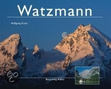
- Watzmann
- Der sagenhafte Watzmann im südöstlichsten Zipfel Deutschlands ist dank seiner markanten Silhouette, seiner berüchtigten Ostwand und nicht zuletzt durch den fantastischen Königssee eines der deutschen Wahrzeichen schlechthin. Wie schafft es ein gerade einmal 2714 Meter hoher Berg zu einem solchen Bekanntheitsgrad, der ihn und den zu seinen Füßen... Leer más
- Also available from:
- Bol.com, Belgium
Belgium
- Watzmann
- Der sagenhafte Watzmann im südöstlichsten Zipfel Deutschlands ist dank seiner markanten Silhouette, seiner berüchtigten Ostwand und nicht zuletzt durch den fantastischen Königssee eines der deutschen Wahrzeichen schlechthin. Wie schafft es ein gerade einmal 2714 Meter hoher Berg zu einem solchen Bekanntheitsgrad, der ihn und den zu seinen Füßen... Leer más

Netherlands
2020
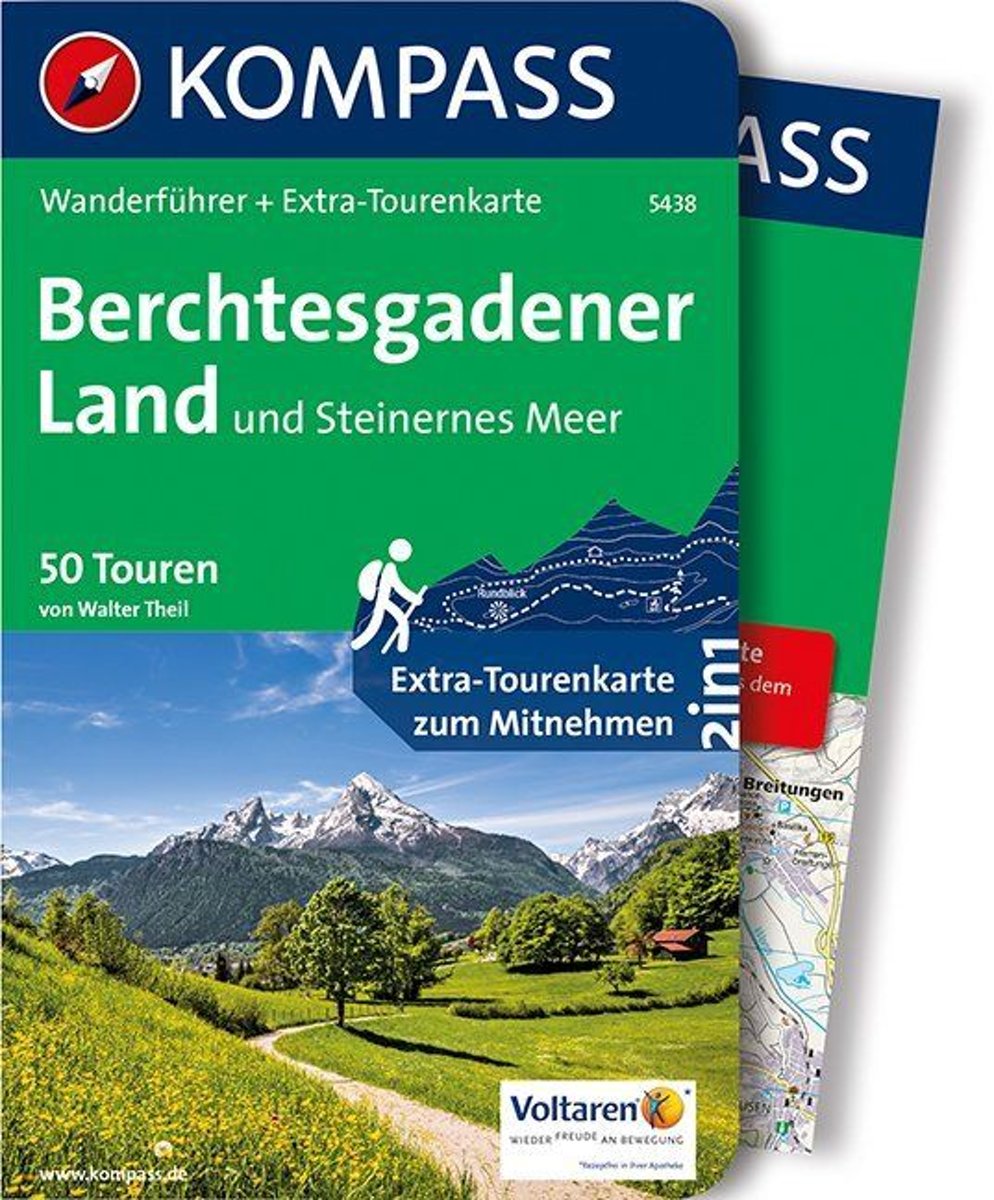
- WF5438 Berchtesgadener Land, Steinernes Meer Kompass
- . Praktische Tourenkarte im Maßstab 1:35000 zum Mitnehmen mit allen eingezeichneten Touren aus dem Wanderführer.. Icons im Farbbalken informieren über Schwierigkeitsgrad, Einkehrmöglichkeit, Kinderfreundlichkeit usw.. Informationen zu Ausgangspunkt, Charakter, Einkehr und Karte sind gleich zu Beginn jeder Tour übersichtlich zusammengefasst..... Leer más
- Also available from:
- Bol.com, Belgium
Belgium
2020
- WF5438 Berchtesgadener Land, Steinernes Meer Kompass
- . Praktische Tourenkarte im Maßstab 1:35000 zum Mitnehmen mit allen eingezeichneten Touren aus dem Wanderführer.. Icons im Farbbalken informieren über Schwierigkeitsgrad, Einkehrmöglichkeit, Kinderfreundlichkeit usw.. Informationen zu Ausgangspunkt, Charakter, Einkehr und Karte sind gleich zu Beginn jeder Tour übersichtlich zusammengefasst..... Leer más
Mapas

United Kingdom
- Goms - Aletsch
- Goms - Aletsch area of the Bernese Oberland at 1:50,000 in a series from Hallwag covering Switzerland’s popular hiking regions on light, waterproof and tear-resistant maps highlighting long-distance paths: the nine national routes plus special regional routes, as well as other local hiking trails.Cartography is similar to that used both in... Leer más

United Kingdom
- Hohe Wand - Schneebergland - Gutenstein Alps - Piestingtal - Lilienfeld F&B WK012
- Hohe Wand - Piestingtal - Triestingtal - Gölsental - Gutensteier Alpen – Lilienfeld area south-west of Vienna presented at 1:50,000 in a series of contoured and GPS compatible outdoor leisure map from Freytag & Berndt with hiking and cycling routes, mountain huts, campsites and youth hostels, local bus stops, plus other tourist information.To... Leer más

United Kingdom
- Styrian Winelands - Southwest Styria F&B WK411
- Styrian Winelands area south-eastern Austria presented at 1:50,000 in a series of contoured and GPS compatible outdoor leisure map from Freytag & Berndt with hiking and cycling routes, mountain huts, campsites and youth hostels, local bus stops, plus other tourist information. To see the list of currently available titles in this series please... Leer más

United Kingdom
- Zell am See - Kaprun - Saalbach F&B WK382
- Zell-am-See - Kaprun - Saalbach area of the Austrian Alps presented at 1:50,000 in a series of contoured and GPS compatible outdoor leisure map from Freytag & Berndt with hiking and cycling routes, mountain huts, campsites and youth hostels, local bus stops, plus other tourist information. To see the list of currently available titles in this... Leer más

United Kingdom
- Lake Constance - Königssee Cycle Route Bikeline Map-Guide
- Lake Constance - Königssee Cycle Route, a 400-km long cycle trail along the whole length of the German Alps from Lindau to Berchtesgaden, presented by the Verlag Esterbauer in a guide with maps at 1:50,000 showing the route and its variants. Extensive information is conveyed by symbols, indicating road surface, campsites and other... Leer más
United Kingdom
- Haslital: Grindelwald - Engelberg 50K Hallwag Outdoor Map No. 5
- Haslital area, from Grindelwald to Engelberg, at 1:50,000 in a series from Hallwag covering Switzerland’s popular hiking regions on light, waterproof and tear-resistant maps highlighting long-distance paths: the nine national routes plus special regional routes, as well as other local hiking trails.Cartography is similar to that used both in... Leer más
United Kingdom
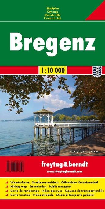
- Bregenz F&B
- Indexed street plan of Bregenz extending north along the Bodensee coast to Lochau and Unter Hochsteg. Detail includes pedestrianised areas, railways, bus routes and cycle paths. Notable buildings are highlighted in red, and symbols indicate post offices, hostels, campsites and car parks.On the reverse is a 1:50,000 contoured map of the... Leer más

United Kingdom
- Cinque Terre - Golfo del Tigullio: La Spezia - Sestri Levante - Rapallo - Genoa 50K IGC Map No. 23
- Cinque Terre - Golfo del Tigullio area of the Italian Riviera from genoa to la Spezia including Sestri Levante and Rapallo in a series contoured hiking maps at 1:50,000 with local trails, long-distance footpaths, mountain accommodation, etc. from the Turin based Istituto Geografico Centrale.Maps in this series have contours at 50m intervals,... Leer más

United Kingdom
- Ebermannstadt E10
- Ebermannstadt in a series of GPS compatible recreational editions of the Bavarian topographic survey at 1:25,000, with waymarked hiking trails and cycling routes, campsites and youth hostels, etc. Coverage includes Gößweinstein, Waischenfeld, Wiesenttal, Pottenstein, Pretzfeld, Heiligenstadt i.OFr.Contours used in this map vary between 5 to 20m... Leer más

United Kingdom
- Hungarian National Long-distance Blue Trail (E4): Visegrad to Irott-ko
- Hiking guide to the north-western section of Hungary’s National Blue Trail which forms part of the E4 European long-distance footpath. The guide covers the route from the historic town of Visegrád on the Danube, across the Buda Hills on the outskirts of Budapest and the Bakony Hills along the north-eastern shore of Lake Balaton, to Írott-ko in... Leer más
United Kingdom
- Montreux
- Montreux - Col du Pillon area at 1:50,000 in a series from Hallwag covering Switzerland’s popular hiking regions on light, waterproof and tear-resistant maps highlighting long-distance paths: the nine national routes plus special regional routes, as well as other local hiking trails.Cartography is similar to that used both in Hallwag’s hiking... Leer más

United Kingdom
- Transrhodopi - Long distance hiking and biking trail From Trigrad to Ivaylovgrad
- Western Rhodope Mountains at 1:100,000 on a contoured GPS compatible map from Domino extending from just west of the Pirin National Park to Asenovgrad in the north-east. The map is double-sided with a good overlap between the sides. Topography is shown by contours at 50m intervals with relief shading and spot heights, plus colouring for... Leer más

United Kingdom
- Berchtesgaden – Bad Reichenhall – Königsee K+F Outdoor Map 8
- Berchtesgaden - Bad Reichenhall - Königsee area of the German Alps at 1:35,000 from Kümmerly+Frey in a series GPS compatible, double-sided maps printed on durable, waterproof and tear-resistant plastic paper; contoured, with hiking and cycle routes, other recreational activities, etc. Maps in this series are at a scale of either 1:50,000 or... Leer más

United Kingdom
- Val Venosta / Vinschgau K+F Outdoor Map 1
- Val Venosta / Vinschgau area in the Dolomites at 1:50,000 in a series of waterproof and tear-resistant, GPS compatible and contoured recreational maps from Kümmerly + Frey with both local and long-distance hiking and cycling trails, ski routes, sites for other outdoor pursuits, accommodation, bus stops, etc. Coverage includes the Ortles/Ortler... Leer más

United Kingdom
- Bad Reichenhall Q17
- Bad Reichenhall in a series of GPS compatible recreational editions of the Bavarian topographic survey at 1:25,000, with waymarked hiking trails and cycling routes, campsites and youth hostels, etc. Coverage includes Salzburg-Süd, Berchtesgaden, Bayerisch Gmain, Bischofswiesen, Marktschellenberg, Piding.Contours used in this map vary between 5... Leer más