Algarve
Descripción
Senderos en región
Enlaces
Datos
Informes
Guías y mapas
Hospedaje
Organizaciones
Operadores turísticos
GPS
Otro
Libros

Stanfords
United Kingdom
2012
United Kingdom
2012
- Algarve Car Tours and Walks - 6th ed.
- Algarve in the Sunflower Landscapes guide series; exploring the best walking and touring possibilities in the region or area. Detailed information about touring by hired car or public transport, as well as on foot is provided, helping walkers to navigate and plan day-trips. Shorter strolls are also included as an alternative for each main route... Leer más

Stanfords
United Kingdom
2015
United Kingdom
2015
- Algarve Sunflower Landscape Guide
- Algarve in the Sunflower Landscapes guide series; exploring the best walking and touring possibilities in the region or area. Detailed information about touring by hired car or public transport, as well as on foot is provided, helping walkers to navigate and plan day-trips. Shorter strolls are also included as an alternative for each main route... Leer más

Stanfords
United Kingdom
2021
United Kingdom
2021
- DK Eyewitness Portugal
- Welcome to Portugal, a sunseekers` paradise.Whether you`re looking for world-renowned beaches, serene hilltop villages, verdant islands, or captivating cities, your DK Eyewitness travel guide makes sure you experience all that Portugal has to offer.Small but immensely varied, Portugal offers countless opportunities for adventure. From the... Leer más

Stanfords
United Kingdom
2019
United Kingdom
2019
- Portugal`s Rota Vicentina: Alentejo and Algarve coastal route
- Guidebook to walking Portugal`s Rota Vicentina, a stunning 220km route down the southwestern Atlantic coast, through the Alentejo and Algarve districts. The route, which is suitable for all fit walkers and is not technically difficult, is described across 12 stages, making it perfect for a two-week holiday.Walkers who appreciate sunny days,... Leer más

Stanfords
United Kingdom
United Kingdom
- Algarve Marco Polo Pocket Travel Guide 2018 - with pull out map
- Marco Polo Pocket Guide Algarve: the Travel Guide with Insider Tips Explore the Algarve with this handy, pocket-sized, authoritative guide, packed with Insider Tips. Discover boutique hotels, authentic restaurants, the region`s trendiest places, and get tips on shopping and what to do on a limited budget. There are plenty of ideas for travel... Leer más

Stanfords
United Kingdom
United Kingdom
- Bournemouth, Purbeck, Wimborne Minster & Ringwood OS Landranger Active Map 195 (waterproof)
- Bournemouth and the Isle of Purbeck area, including part of the New Forest National Park and a section of the South West Coast Path / E9 European Long-distance Path, on a waterproof and tear-resistant OS Active version of map No. 195 from the Ordnance Survey’s Landranger series at 1:50,000, with contoured and GPS compatible topographic mapping... Leer más

Stanfords
United Kingdom
United Kingdom
- The Solent, Isle of Wight, Southampton & Portsmouth OS Landranger Active Map 196 (waterproof)
- Isle of Wight with the Southampton - Portsmouth area, including part of the New Forest National Park and a section of the E9 European Long-distance Path, on a waterproof and tear-resistant OS Active version of map No. 196 from the Ordnance Survey’s Landranger series at 1:50,000, with contoured and GPS compatible topographic mapping plus tourist... Leer más

Stanfords
United Kingdom
United Kingdom
- Eastbourne, Hastings, Crowborough, Battle & Heathfield OS Landranger Active Map 199 (waterproof)
- Eastbourne and Hastings area, including the Seven Sisters and sections of the South Downs Way and the E9 European Long-distance Path, on a waterproof and tear-resistant OS Active version of map No. 199 from the Ordnance Survey’s Landranger series at 1:50,000, with contoured and GPS compatible topographic mapping plus tourist information.MOBILE... Leer más

The Book Depository
United Kingdom
2019
United Kingdom
2019
- Shorter Treks in the Pyrenees
- 7 great one and two week circular treks Leer más
- Also available from:
- De Zwerver, Netherlands

De Zwerver
Netherlands
2019
Netherlands
2019
- Wandelgids Shorter Treks in the Pyrenees | Cicerone
- Guidebook detailing seven circular treks of 4-12 days in the beautiful Pyrenees. The varied routes cover both sides of the French-Spanish border and include both the High Pyrenees and the lower, more gentle mountains of the Basque Country and Catalonia. Variants are suggested for those wishing to shorten or extend the treks. Leer más

Stanfords
United Kingdom
United Kingdom
- Chichester, South Downs, Bognor Regis & Arundel OS Landranger Map 197 (paper)
- Chichester and Bognor Regis area, including the South Downs National Park and a section of the South Downs Way / E9 European Long-distance Path, on a paper version of map No. 197 from the Ordnance Survey’s Landranger series at 1:50,000, with contoured and GPS compatible topographic mapping plus tourist information.MOBILE DOWNLOADS: As well as... Leer más
- Also available from:
- The Book Depository, United Kingdom
- De Zwerver, Netherlands


De Zwerver
Netherlands
Netherlands

Stanfords
United Kingdom
United Kingdom
- Dorchester, Weymouth, Cerne Abbas & Bere Regis OS Landranger Active Map 194 (waterproof)
- Dorchester and Weymouth area, including a section of the South West Coast Path / E9 European Long-distance Path, on a waterproof and tear-resistant OS Active version of map No. 194 from the Ordnance Survey’s Landranger series at 1:50,000, with contoured and GPS compatible topographic mapping plus tourist information.MOBILE DOWNLOADS: As well as... Leer más
- Also available from:
- The Book Depository, United Kingdom


Stanfords
United Kingdom
United Kingdom
- Canterbury, East Kent, Dover & Margate OS Landranger Map 179 (paper)
- Eastern Kent with Canterbury, Dover and Margate, including sections of the North Downs Way and the E2 and E9 European Long-Distance Paths, on a paper version of map No. 179 from the Ordnance Survey’s Landranger series at 1:50,000, with contoured and GPS compatible topographic mapping plus tourist information.MOBILE DOWNLOADS: As well as the... Leer más
- Also available from:
- The Book Depository, United Kingdom
- De Zwerver, Netherlands


De Zwerver
Netherlands
Netherlands

Stanfords
United Kingdom
United Kingdom
- Brighton, Lewes, Worthing, Horsham & Haywards Heath OS Landranger Map 198 (paper)
- Brighton and Lewes area, including the South Downs National Park and a section of the South Downs Way / E9 European Long-distance Path, on a paper version of map No. 198 from the Ordnance Survey’s Landranger series at 1:50,000, with contoured and GPS compatible topographic mapping plus tourist information.MOBILE DOWNLOADS: As well as the... Leer más
- Also available from:
- The Book Depository, United Kingdom
- De Zwerver, Netherlands


De Zwerver
Netherlands
Netherlands

The Book Depository
United Kingdom
2005
United Kingdom
2005
- Algarve walking guide 2018
- The Finest Valley and Mountain Walks - ROTH.E4825 Leer más

Stanfords
United Kingdom
United Kingdom
- Ashford, Romney Marsh, Rye & Folkestone OS Landranger Map 189 (paper)
- Ashford and Romney Marsh area, including sections of the North Downs Way and the E9 European Long-distance Path, on a paper version of map No. 189 from the Ordnance Survey’s Landranger series at 1:50,000, with contoured and GPS compatible topographic mapping plus tourist information.MOBILE DOWNLOADS: As well as the physical edition of the map,... Leer más
- Also available from:
- The Book Depository, United Kingdom
- De Zwerver, Netherlands


De Zwerver
Netherlands
Netherlands
Mapas

Stanfords
United Kingdom
United Kingdom
- Ordesa - Monte Perdido National Park Editorial Alpina 2-Map Set
- Ordesa and Monte Perdido National Park at 1:25,000 in a set of two GPS compatible recreational maps in an extensive and very popular series from Editorial Alpina, providing more detailed coverage of this popular hiking area.Contours are at 10m intervals, with relief shading and vegetation colouring. An overprint highlights waymarked PR hiking... Leer más

Stanfords
United Kingdom
United Kingdom
- Barcelona and Environs ICGC 100K 5
- Barcelona and Environs map at 1:100,000 in the topographic survey of Catalonia published by the Institut Cartogràfic de Catalunya, with very detailed coverage of a large area and an excellent representation of the region’s topography. Maps in this series have relief presented by contours at 40m intervals, enhanced by additional hill-shading and... Leer más

Stanfords
United Kingdom
United Kingdom
- Comarques Centrales
- Comarques Centrales, the foothills of the Catalan Pyrenees including Ripoll, Olot, Berga, Vic, Solsona, etc, at 1:100,000 in the topographic survey of Catalonia published by the Institut Cartogràfic de Catalunya, with very detailed coverage of a large area and an excellent representation of the region’s topography.Maps in this series have... Leer más

Stanfords
United Kingdom
United Kingdom
- Costa Vicentina 2-Map Set F&B WKP4
- The ”Costa Vicentina” hiking map set shows the most famous Portuguese long-distance hiking trail on a scale of 1:50,000. The entire region around the picturesque Rota Vicentina is shown in great detail on 4 sheets. Hikers will find all the important information they need to walk the Fisherman`s Trail and the Historical Trail in full or in... Leer más

Stanfords
United Kingdom
United Kingdom
- Pirineu Oriental - Girona - Costa Brava
- Pirineu Oriental - Girona - Costa Brava map, covering the eastern part of the Catalan Pyrenees and the coast southwards to Pineda de Mar at 1:100,000 in the topographic survey of Catalonia published by the Institut Cartogràfic de Catalunya, with very detailed coverage of a large area and an excellent representation of the region’s topography.... Leer más

Stanfords
United Kingdom
United Kingdom
- La Senda de Camille Editorial Alpina
- La Senda de Camille, the Pyrenean Bear Trail, a 104-km circuit in the central Pyrenees, on a contoured GPS compatible map at 1:25,000 from Editorial Alpina, plus a booklet providing information on mountain refuges. The route, which crosses over from the Spanish side to the Parc National des Pyrénées in France and incorporates part of the... Leer más

Stanfords
United Kingdom
United Kingdom
- GR 11: La Senda
- GR11 long-distance footpaths along the Spanish side of the Pyrenees in a French language guide from Rando Editions, with extracts from the publisher’s topographic series at 1:50,000 highlighting the route and mountain refuges.The guide divides the route into 40 sections and covers it from the Mediterranean, starting at Cap de Creus on the Costa... Leer más
Stanfords
United Kingdom
United Kingdom
- Terres de l`Ebre
- Terres de l`Ebre map at 1:100,000 in the topographic survey of Catalonia published by the Institut Cartogràfic de Catalunya, with very detailed coverage of a large area and an excellent representation of the region’s topography. Maps in this series have relief presented by contours at 40m intervals, enhanced by additional hill-shading and spot... Leer más

Stanfords
United Kingdom
United Kingdom
- Hungarian National Long-distance Blue Trail (E7): Irott-ko to Szekszard
- Hiking guide to the western section of Hungary’s National Blue Trail, including part of the E7 European long-distance footpath. The guide covers the route from Írott-ko in the Koszegi range on the Austrian border, across the Orség National Park and the Mecsek Hills near Pécs, to Szekszárd. At the border crossing with Slovakia near... Leer más
Stanfords
United Kingdom
United Kingdom
- Pla de Lleida
- Pla de Lleida map at 1:100,000 in the topographic survey of Catalonia published by the Institut Cartogràfic de Catalunya, with very detailed coverage of a large area and an excellent representation of the region’s topography. Maps in this series have relief presented by contours at 40m intervals, enhanced by additional hill-shading and spot... Leer más
Stanfords
United Kingdom
United Kingdom
- Pirineu Occidental
- Pirineu Occidental, the western part of the Catalan Pyrenees, at 1:100,000 in the topographic survey of Catalonia published by the Institut Cartogràfic de Catalunya, with very detailed coverage of a large area and an excellent representation of the region’s topography.Maps in this series have relief presented by contours at 40m intervals,... Leer más
Stanfords
United Kingdom
United Kingdom
- Camp de Tarragona
- Camp de Tarragona map at 1:100,000 in the topographic survey of Catalonia published by the Institut Cartogràfic de Catalunya, with very detailed coverage of a large area and an excellent representation of the region’s topography. Maps in this series have relief presented by contours at 40m intervals, enhanced by additional hill-shading and spot... Leer más

Stanfords
United Kingdom
United Kingdom
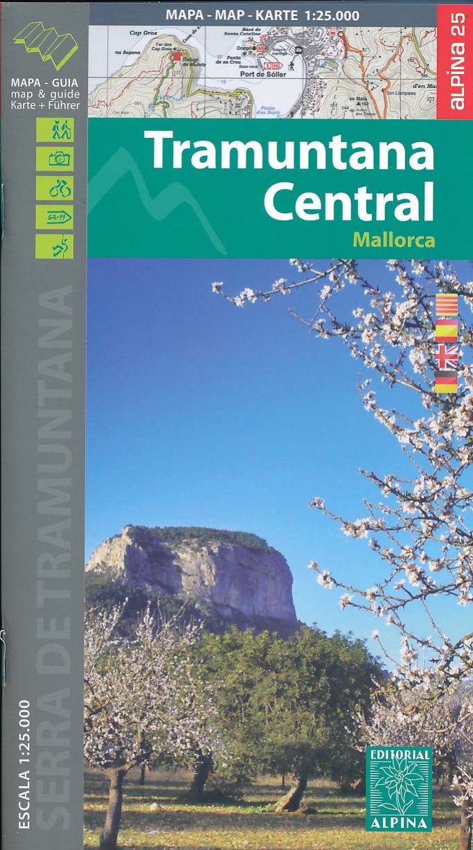
- Mallorca - Tramuntana Central Editorial Alpina
- The central part of Mallorca’s Serra de Tramuntana mountains on a contoured and GPS-compatible map at 1:25,000 from Editorial Alpina, highlighting numerous local hiking trails and the course of the GR221 long-distance trail, climbing and canyoning sites, refuges and campsites, etc. Accompanying booklet includes English-language descriptions of... Leer más
- Also available from:
- The Book Depository, United Kingdom
- De Zwerver, Netherlands

The Book Depository
United Kingdom
United Kingdom
- Mallorca -Tramuntana Central GR11 Map and Hiking Guide
- Zeer gedetailleerde wandelkaart van een deel van de Tramuntana op Mallorca. Met ingetekende wandelroutes en andere informatie. uitstekende kaart. Met symbolen voor campings, hutten. Let op: deze uitgever is traag met het vernieuwen van kaarten; het kan zo maar zijn dat een bepaalde kaart gedurende langere tijd niet beschikbaar is. Majorca:... Leer más
De Zwerver
Netherlands
Netherlands
- Wandelkaart 67 Tramuntana Central - Mallorca | Editorial Alpina
- Zeer gedetailleerde wandelkaart van een deel van de Tramuntana op Mallorca. Met ingetekende wandelroutes en andere informatie. uitstekende kaart. Met symbolen voor campings, hutten. Let op: deze uitgever is traag met het vernieuwen van kaarten; het kan zo maar zijn dat een bepaalde kaart gedurende langere tijd niet beschikbaar is. Majorca:... Leer más

Stanfords
United Kingdom
United Kingdom
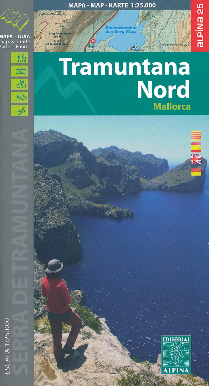
- Mallorca - Tramuntana North Editorial Alpina
- The northern part of Mallorca’s Serra de Tramuntana mountains on a contoured and GPS-compatible map at 1:25,000 from Editorial Alpina, highlighting numerous local hiking trails and the course of the GR221 long-distance trail, climbing and canyoning sites, refuges and campsites, etc. Accompanying booklet includes English-language descriptions of... Leer más
- Also available from:
- The Book Depository, United Kingdom
- De Zwerver, Netherlands

The Book Depository
United Kingdom
United Kingdom
- Mallorca -Tramuntana Norte GR11 map and hiking guide
- Zeer gedetailleerde wandelkaart van een deel van de Tramuntana op Mallorca. Met ingetekende wandelroutes en andere informatie. uitstekende kaart. Met symbolen voor campings, hutten. Let op: deze uitgever is traag met het vernieuwen van kaarten; het kan zo maar zijn dat een bepaalde kaart gedurende langere tijd niet beschikbaar is. Majorca:... Leer más
De Zwerver
Netherlands
Netherlands
- Wandelkaart 68 Tramuntana Noord GR221 Mallorca | Editorial Alpina
- Zeer gedetailleerde wandelkaart van een deel van de Tramuntana op Mallorca. Met ingetekende wandelroutes en andere informatie. uitstekende kaart. Met symbolen voor campings, hutten. Let op: deze uitgever is traag met het vernieuwen van kaarten; het kan zo maar zijn dat een bepaalde kaart gedurende langere tijd niet beschikbaar is. Majorca:... Leer más

Stanfords
United Kingdom
United Kingdom
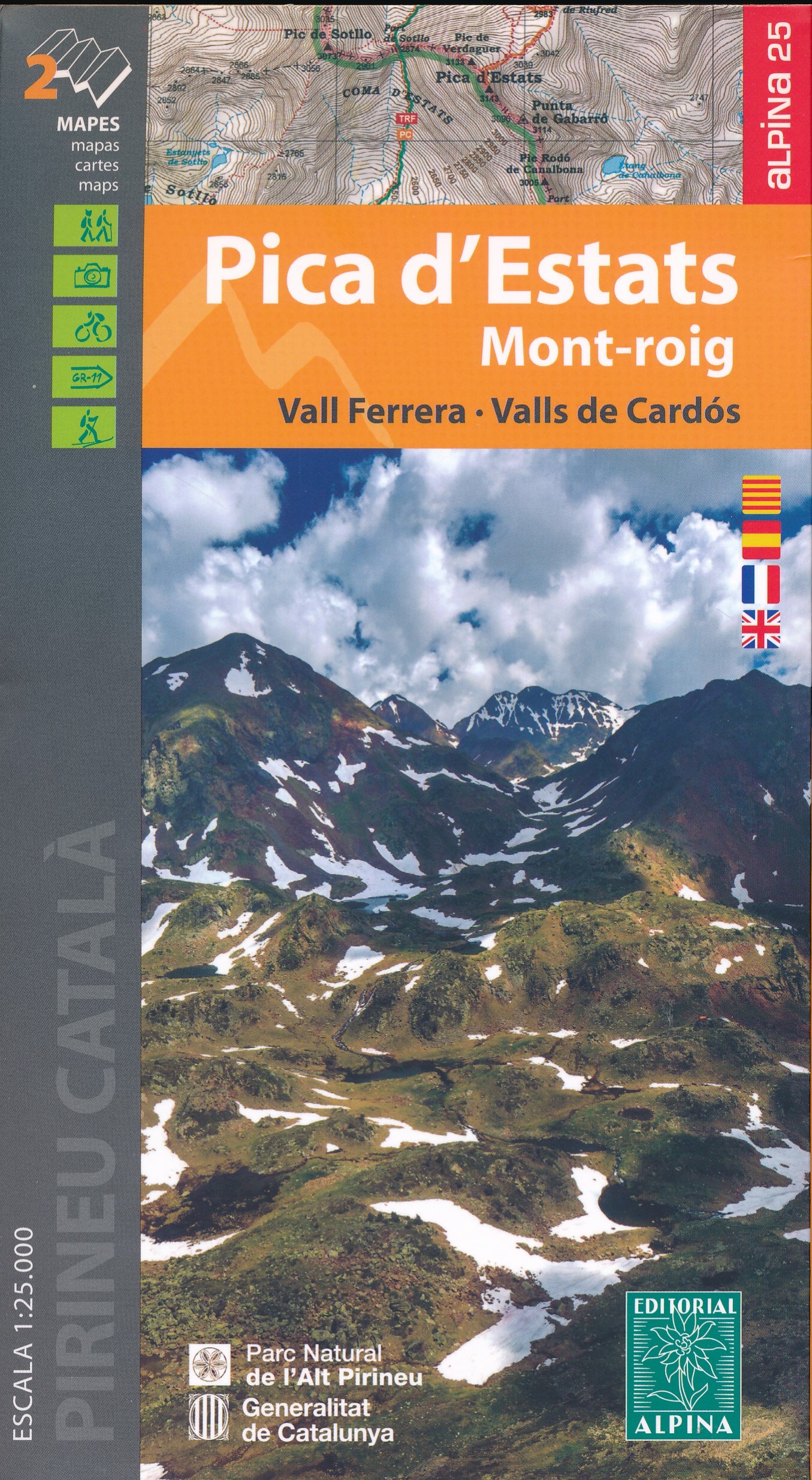
- Pica d`Estats - Mont-roig - Vall Ferrera - Valls de Cardos Editorial Alpina 2-Map Set
- Pica d`Estats - Mont-roig area of the Catalan Pyrenees just west of Andorra on a contoured and GPS-compatible map at 1:25,000 from Editorial Alpina, highlighting local and long-distance hiking trails, tourist accommodation, etc. Coverage extends from the Andorran border westwards beyond the peak of Mont-roig and from the French border south to... Leer más
- Also available from:
- The Book Depository, United Kingdom
- De Zwerver, Netherlands