Stanfords
United Kingdom

Stanfords
United Kingdom
- Monte Rosa Freeride Map
- The best rides in the freeride hot spots of the Alps – this is the simple formula of the Freeride Maps. The first map available to freeriders is making the locals freeride knowledge available to a broad public.All ridable slopes, drops and couloirs are marked as freeride corridors in different colours for three difficulty ratings: blue for... Leer más

Stanfords
United Kingdom
- Valle Anzasca - Monte Rosa - Macugnaga Geo4Map 5
- 1:25,000 hiking map covering the west end of the Valle Anzasca, centred on Macugnaga, including Monte Rosa, Corno Rosso and Carcoforo. Published in association with the CAI, the Italian Alpine Club, who are responsible for the hiking trails. Trails are marked on the map. The key information and more detailed information on the rear of the sheet... Leer más

Stanfords
United Kingdom

Stanfords
United Kingdom

Stanfords
United Kingdom
- Tour del Monte Rosa Map-Guide
- 1:25,000 scale hiking map around the Monte Rosa.Published in association with the CAI, the Italian Alpine Club, who are responsible for the trails. Trails are marked on the map. Printed on waterproof, tear-proof paper.Please note that the key information and more detailed information on the rear is only in Italian.206 kilometers of path, 10... Leer más

Stanfords
United Kingdom
- Val Brembana - Valsassina - Le Grigne: Lecco - Bergamo 50K IGC Map No. 22
- Val Brembana - Valsassina - Le Grigne area including Lecco and Bergamo in a series contoured hiking maps at 1:50,000 with local trails, long-distance footpaths, mountain accommodation, etc. from the Turin based Istituto Geografico Centrale.Maps in this series have contours at 50m intervals, enhanced by shading and graphic relief. An overprint... Leer más

Stanfords
United Kingdom

Stanfords
United Kingdom
- Lanzo - Viù - Chialamberto - Locana 25K IGC Map No. 110
- Lanzo - Viù - Chialamberto - Locana – Cirié – Basse Valli di Lanzo area at 1:25,000 in a series of contoured, GPS compatible walking maps from the Turin based Istituto Geografico Centrale, highlighting hiking trails including long-distance routes, ski routes and alpine accommodation. Maps in this series have contours at 25m intervals, enhanced... Leer más

Stanfords
United Kingdom
- San Remo - Imperia - Monte Carlo IGC 14
- The westernmost part of the Italian Riviera with coverage extending from Monte Carlo to Imperia and northwards to Tende, in a series contoured hiking maps at 1:50,000 with local trails, long-distance footpaths, mountain accommodation, etc. from the Turin based Istituto Geografico Centrale.Maps in this series have contours at 50m intervals,... Leer más

Stanfords
United Kingdom
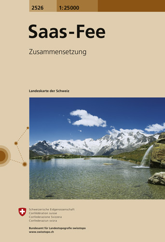
- Saas-Fee Swisstopo 2526
- Map No. 2526, Saas-Fee, in the topographic survey of Switzerland at 1:25,000 from Swisstopo, covering the central part of the Mischabel range and both sides of the two adjoining valleys: the Mattertal between Zermatt and St Niklaus and the Saastal from north of Saas-Balen to the Mattmark Reservoir. Please note: Zermatt is at the southern edge... Leer más
De Zwerver
Netherlands
- Wandelkaart - Topografische kaart 2526 Saas - Fee | Swisstopo
- Map No. 2526, Saas-Fee, in the topographic survey of Switzerland at 1:25,000 from Swisstopo, covering the central part of the Mischabel range and both sides of the two adjoining valleys: the Mattertal between Zermatt and St Niklaus and the Saastal from north of Saas-Balen to the Mattmark Reservoir. Please note: Zermatt is at the southern edge... Leer más

Stanfords
United Kingdom
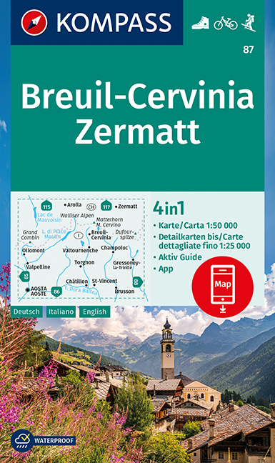
- Breuil-Cervinia - Zermatt Kompass 87
- Breuil-Cervinia - Matterhorn - Zermatt area straddling the border of Italy and Switzerland on a GPS compatible hiking and recreational map at 1:50,000 from Kompass, printed on durable, waterproof and tear-resistant synthetic paper. Coverage extends north to Arolla and east to Monte Rosa, with Aosta in the south-western corner of the map, and... Leer más
De Zwerver
Netherlands
- Wandelkaart 87 Breuil-Cervinia - Zermatt | Kompass
- Breuil-Cervinia - Matterhorn - Zermatt area straddling the border of Italy and Switzerland on a GPS compatible hiking and recreational map at 1:50,000 from Kompass, printed on durable, waterproof and tear-resistant synthetic paper. Coverage extends north to Arolla and east to Monte Rosa, with Aosta in the south-western corner of the map, and... Leer más

Stanfords
United Kingdom
- Genoa - Varazze - Ovada 50K IGC Map No. 16
- The coast of the Italian Riviera and its hinterland around Genoa in a series contoured hiking maps at 1:50,000 with local trails, long-distance footpaths, mountain accommodation, etc. from the Turin based Istituto Geografico Centrale.Maps in this series have contours at 50m intervals, enhanced by shading and graphic relief. An overprint... Leer más

De Zwerver
Netherlands
- Wandelkaart 16 Genova, Genua, Varazze, Ovada | IGC - Istituto Geografico Centrale
- Genoa - Varazze - Ovada, map no. 16, in a series contoured hiking maps at 1:50,000 with local trails, long-distance footpaths, mountain accommodation, etc. from the Turin based Istituto Geografico Centrale covering the Italian Alps and Piedmont, the lakes and northern Lombardy, and the Italian Riviera.The maps have contours at 50m intervals,... Leer más

Stanfords
United Kingdom
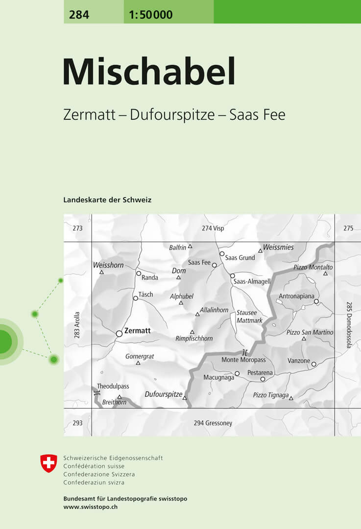
- Mischabel Swisstopo 284
- Mischabel, map No. 284, in the standard topographic survey of Switzerland at 1:50,000 from Swisstopo, i.e. without the special overprint highlighting walking trails, local bus stops, etc, presented in Swisstopo’s hiking editions of the 50K survey. The map covers the southern part of the Mattertal with Zermatt and Randa, the Saastal with Saas... Leer más

Stanfords
United Kingdom
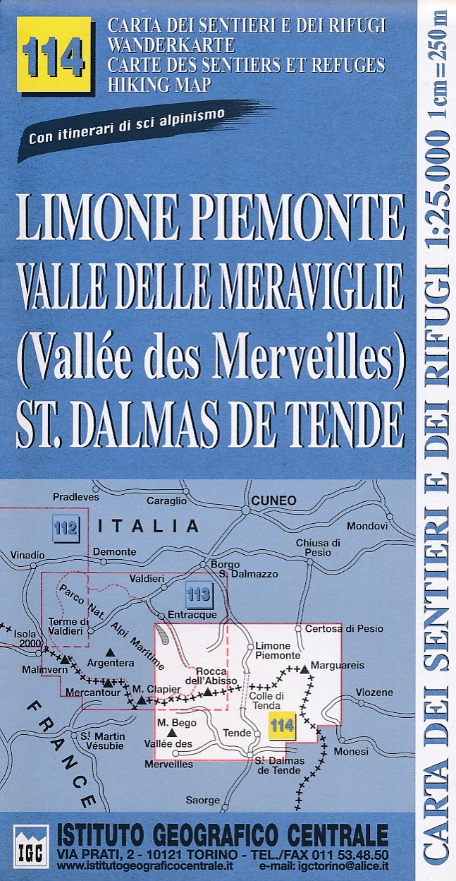
- Limone Piemonte - Vallée des Merveilles 25K IGC Map No. 114
- Limone Piemonte - Vallée des Merveilles area at 1:25,000 in a series of contoured, GPS compatible walking maps from the Turin based Istituto Geografico Centrale, highlighting hiking trails including long-distance routes, ski routes and alpine accommodation. Maps in this series have contours at 25m intervals, enhanced by shading and graphic... Leer más