Stanfords
United Kingdom
- Sappada - S. Stefano - Forni Avoltri Tabacco 01
- Sappada - S. Stefano - Forni Avoltri area in a series of Tabacco maps at 1:25,000 covering the Dolomites and the mountains of north-eastern Italy - Stanfords’ most popular coverage for this region, with excellent cartography and extensive overprint for hiking routes and other recreational activities, local bus stops, etc. Additional overprint... Leer más

Stanfords
United Kingdom
- Il Monferrato: Asti - Casale Monferrato 50K IGC Map No. 20
- The Monferrato region of Piedmont east of Turin, between Asti and Casale Monferrato, in a series contoured hiking maps at 1:50,000 with local trails, long-distance footpaths, mountain accommodation, etc. from the Turin based Istituto Geografico Centrale. This title also shows local cycle routes.Maps in this series have contours at 50m... Leer más

Stanfords
United Kingdom
- Valsugana - Trento - Piné - Levico - Lavarone Kompass 75
- Valsugana - Trento - Piné - Levico – Lavarone area of southern Dolomites on a GPS compatible hiking and recreational map at 1:50,000 from Kompass, printed on durable, waterproof and tear-resistant synthetic paper. On the reverse is a panorama of the Trentino region, extending from Monte Baldo and the northern part of Lake Garda northwards to... Leer más

Stanfords
United Kingdom
- Bassa Val Tanaro - Val Bormida e Cebano
- Val Vermenagna - Valle Pesio - Alta Valle Ellero area of the Italian Alps presented at 1:25,000 in a series of large, contoured and GPS compatible walking maps from Fraternali Editore, printed on light, waterproof and tear-resistant synthetic paper. Maps in this series have topography shown by contour lines at 5m intervals with relief shading,... Leer más

Stanfords
United Kingdom
- Val Susa - Val Cenischia - Rocciamelone - Val Chisone
- Val Susa - Val Cenischia - Rocciamelone - Val Chisone area of the Italian Alps presented at 1:25,000 in a series of large, contoured and GPS compatible walking maps from Fraternali Editore, printed on light, waterproof and tear-resistant synthetic paper. Maps in this series have topography shown by contour lines at 5m intervals with relief... Leer más

Stanfords
United Kingdom
- Monte Grappa - Basano - Feltre Tabacco 051
- Monte Grappa - Basano - Feltre in a series of Tabacco maps at 1:25,000 covering the Dolomites and the mountains of north-eastern Italy - Stanfords’ most popular coverage for this region, with excellent cartography and extensive overprint for hiking routes and other recreational activities, local bus stops, etc. Additional overprint in this... Leer más

Stanfords
United Kingdom
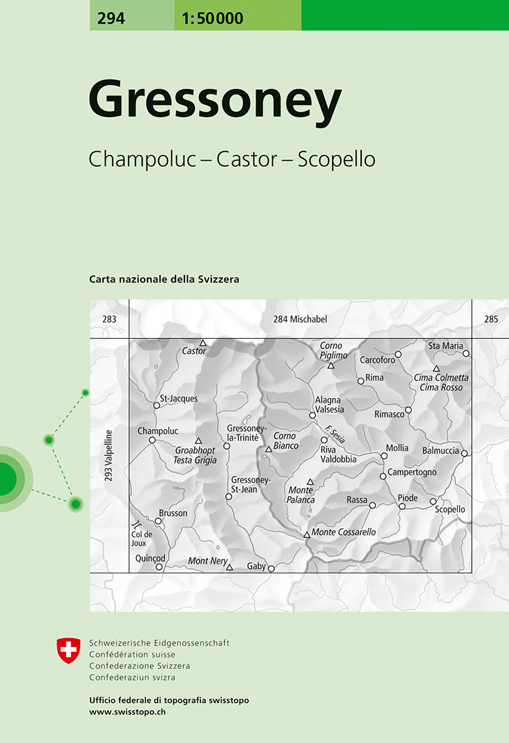
- Gressoney Swisstopo 294
- Gressoney, map No. 294, in the standard topographic survey of Switzerland at 1:50,000 from Swisstopo, i.e. without the special overprint highlighting walking trails, local bus stops, etc, presented in Swisstopo’s hiking editions of the 50K survey. The map covers mainly the Italian side of the border, with only a small part of Switzerland shown... Leer más

Stanfords
United Kingdom
- Livigno and Environs
- Livigno and its environs on a detailed, contoured and GPS compatible map at 1:25,000 from Litografia Artistica Cartographical in their Global Map imprint, highlighting hiking trails, huts, ski lifts, etc. The map is double-sided, with a very generous overlap, and extends from the Swiss approaches to the Lago di Livigno Dam to Rifigio Dosde, and... Leer más
Stanfords
United Kingdom
- Bassa Valle Varaita - Bassa Valle Maira Fraternali Editore 12
- Bassa Valle Varaita - Bassa Valle Maira in the Italian Alps presented at 1:25,000 in a series of large, contoured and GPS compatible walking maps from Fraternali Editore, printed on light, waterproof and tear-resistant synthetic paper. Maps in this series have topography shown by contour lines at 5m intervals with relief shading, spot heights,... Leer más

Stanfords
United Kingdom
- Interlaken - Grindelwald - Lauterbrunnen - Wengen - Brienz Swisstopo SKI 254S
- Detailed ski map at 1:50,000 from Swisstopo, the country’s national survey organization, showing routes for skiing and/or snowboarding, access by public transport, recommended itineraries, lists of mountain huts, etc. The series uses the cartography of Switzerland’s topographic survey, with additional colouring to show slopes steeper than 30°.... Leer más

Stanfords
United Kingdom
- Monte Lessini - Lessinia Tabacco 059
- Monte Lessini – Lessinia area in a series of Tabacco maps at 1:25,000 covering the Dolomites and the mountains of north-eastern Italy - Stanfords’ most popular coverage for this region, with excellent cartography and extensive overprint for hiking routes and other recreational activities, local bus stops, etc. Additional overprint in this title... Leer más

Stanfords
United Kingdom
- Costa degli Dei - Tropea - Vibo Valentia Global Map Tourist Map
- The Horn of Calabria: Costa degli Dei - Tropea - Vibo Valentia at 1:50,000 on a detailed contoured map from LAC in their GlobalMap imprint, highlighting the area’s numerous beaches, campsites, and other places of interest.Topography is shown by relief shading with colouring for woodlands and names of many geographical features. Road network... Leer más

Stanfords
United Kingdom
- San Remo - Imperia - Monte Carlo IGC 14
- The westernmost part of the Italian Riviera with coverage extending from Monte Carlo to Imperia and northwards to Tende, in a series contoured hiking maps at 1:50,000 with local trails, long-distance footpaths, mountain accommodation, etc. from the Turin based Istituto Geografico Centrale.Maps in this series have contours at 50m intervals,... Leer más

Stanfords
United Kingdom
- Valle Anzasca - Vanzone - Piedimulera SUPERCEDED
- 1:25,000 hiking map covering the east end of the Valle Anzasca, centred on Pieve Vergonte, including Villadossola and Anzola d`Ossola. Published in association with the CAI, the Italian Alpine Club, who are responsible for the hiking trails. Trails are marked on the map. The key information and more detailed information on the rear of the sheet... Leer más

Stanfords
United Kingdom
- Il Cuneese: Cuneo - Saluzzo - Carmagnola 75K IGC Map No. 24
- Il Cuneese area of Piedmont, including Cuneo, Saluzzo and Carmagnola, at 1:75,000 in a series contoured hiking maps with local trails, long-distance footpaths, mountain accommodation, etc. from the Turin based Istituto Geografico Centrale. This title also includes an overprint showing cycle routes.Maps in this series have contours at 50m... Leer más