
London
Descripción
Capital of the United Kingdom. All sorts of walks. The Thames Path runs right through the city center and you can hop on the London Eye after being fooled at the ticket counter and view forward and backward on your trail.
Senderos en región
Enlaces
Datos
Informes
Guías y mapas
Hospedaje
Organizaciones
Operadores turísticos
GPS
Otro
Libros

Stanfords
United Kingdom
United Kingdom
- London`s City Churches
- `London`s City Churches` include some of the Capital`s finest architecture. The sanctity of the church has prevented London s churches from being redeveloped or altered in any significant way and so they remain historical islands while the environment around them has changed beyond recognition. This guide is packed with information about the... Leer más

Stanfords
United Kingdom
United Kingdom
- Walking the Canals of London
- Walking the Canals of London by John Merrill is a guidebook to walking the capitals inland waterways. Starting from the Limehouse Basin, the walks fully explore Regent’s canal, the Paddington branch of the Grand Union Canal, the Hanwell Flight and the River Thames from Richmond to Limehouse Basin - thereby completing the London Canal Loop. One... Leer más

Stanfords
United Kingdom
United Kingdom
- London Mini Map Bensons MapGuides
- London Mini Map from Bensons MapGuides in their range of street plans of central London. This title is double-sided with the main map and a diagram of the Underground network on one side plus on the reverse: additional maps of bus routes and London’s theatreland, brief descriptions of main shopping areas and street markets, a street index with... Leer más

Stanfords
United Kingdom
United Kingdom
- People in London: One Photographer. Five Years. The Life of a City.
- London is one of the world`s greatest cities. Filled with people of all races, religions and nationalities, and packed with energy, it is a dynamic melting pot and a colourful testimony to the human spirit. Over five years, photographer Richard Slater has traversed the streets of the city, photographing, meeting and talking with ordinary... Leer más

Stanfords
United Kingdom
United Kingdom
- London Street Trees
- Three years ago the idea of a whole book about London`s street trees seemed somewhat esoteric - weren`t they all just London Planes? But Paul Wood`s brilliant and acclaimed book has gone on to sell 5,000 copies in three printings, and become a fixture in London`s bookshops and museum and gallery gift shops, while the author is still busy... Leer más

Stanfords
United Kingdom
United Kingdom
- Vauxhall
- Police, methylated tramps, Nigerian royalty, gypsies, Irish aunts, teachers, thieves, cockneys and homesick Jamaicans clamour for young Michael`s attention. His world is bursting with all walks of Lambeth life in the early 1970s. Among the terraces, railway arches, bombsites and river mud of Vauxhall, he discovers the meaning of slum... Leer más

Stanfords
United Kingdom
United Kingdom
- Andrew Duncan`s Favourite London Walks
- Andrew Duncan’s Favourite London Walks contains 50 classic routes around the capital, exploring London’s heritage from its busiest central streets to its quiet rural corners. The guide is aimed at both residents and visitors, containing detailed text on the history behind London’s landscape and the people who have shaped it, aswell as visitor... Leer más

Stanfords
United Kingdom
United Kingdom
- The Island House: Our Wild New Life on a Tiny Cornish Isle
- `In the January dark, a young man walks slowly into the sea. He can`t see where he is going, but he knows the island is calling...`Mary and Patrick`s dream was to live in London, have 2.4 children, the nice house, the successful jobs. But life had other plans, and in one traumatic year that all came crashing down.Bruised and battered, Mary... Leer más

Stanfords
United Kingdom
United Kingdom
- London Bensons MapGuides Street Map
- London Street Map - with the most detailed mapping, highly recommended for exploring London on foot - from Bensons MapGuides in their range of street plans of central London. On one side is the publishers’ standard mapping, presented here at 1:9,700 approx, plus a bus map and an index of places of interest with grading. Coverage extends,... Leer más

Stanfords
United Kingdom
United Kingdom
- DK Eyewitness Great Britain
- Discover Great Britain - a beautiful land rich in culture and history. Whether you want to go wild swimming in the Fairy Pools of Skye, take a windswept walk along the Jurassic Coast, or scale the heights of Snowdonia, your DK Eyewitness travel guide makes sure you experience all that Great Britain has to offer.From the jagged peaks of the... Leer más

Stanfords
United Kingdom
United Kingdom
- South Downs - 20 Country Walks For All The Family
- Batsford`s Walking Guides is an exciting new gift series of walking books, aimed at the weekend, family walker. These small-format, portable, hardback books have an attractive retro feel, with nostalgic line drawings and hand-drawn maps. Each of the 20 walks have been carefully selected to appeal to family walkers, most are circular and none... Leer más

Stanfords
United Kingdom
United Kingdom
- Walking London`s Statues and Monuments
- Walking London’s Statues and Monuments is Rupert Hill’s illustrated tour guide of London’s public art, presented in 13 fact-filled walks in the capital. Elegant colour-washed pen and ink illustrations bring the en-route statues and monuments to life. Each art work/site is accompanied by an insight into the history behind its creation, giving an... Leer más

Stanfords
United Kingdom
United Kingdom
- Railway Walks: LMS
- Jeff Vinter, consultant to the BBC`s popular ”Railway Walks” series, here provides a detailed guide to ten of the best railway walks in the territory of the former London Midland and Scottish Railway. These range from the Midland Railway`s express line through the Peak District to the incredible Cromford and High Peak Railway, built before... Leer más

Stanfords
United Kingdom
United Kingdom
- Dickens`s London
- Few novelists have written so intimately about a city in the way that Charles Dickens wrote about London. A near-photographic memory made his contact with the city indelible from a very young age and it remained his constant focus. Virginia Woolf maintained that, `we remodel our psychological geography when we read Dickens,` as he produces... Leer más

Stanfords
United Kingdom
United Kingdom
- Walks in the London Borough of Enfield - Volume 1
- Walks in the London Borough of Enfield Volume 1 by John Merrill is a guidebook to walking in London’s most northerly borough. With some 40 miles of footpaths - including parts of the London Loop, River Lee Navigation path, Pymmes Brook Trail and the New River Path - the Borough of Enfield has much to offer the walker. This guide lists twelve... Leer más
Mapas

Stanfords
United Kingdom
United Kingdom
- London West 1920
- Map No. 176, London West 1920, in the Cassini Historical Series of old Ordnance Survey mapping of England and Wales at 1:50,000 in a format designed to offer a convenient comparison with the present day coverage from the OS, and most locations in three different editions. Old historical maps have been combined so that the sheet lines correspond... Leer más
Stanfords
United Kingdom
United Kingdom
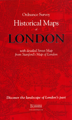
- London Historical Maps Box Set (5-map set)
- London Historical Set of five maps in the Cassini Historical Series reproducing old Ordnance Survey mapping of England and Wales at 1:50,000. The set consists of the four Cassini maps showing the capital between 1805 and 1948, and has as a bonus map a reproduction of Stanfords street plan London at six inches to one mile from 1891.The four... Leer más

Stanfords
United Kingdom
United Kingdom
- London High 5 Edition Street Plan
- The first water-resistant “Comfort Map“ with direct access to useful additional information from the InternetLondon in a scale of 1:20,000 including tourist destinations (Hampstead Heath, Olympic Park and Greenwich) presented on a practical map; inclusive of the High 5 Edition app technology for calling up additional travel information and many... Leer más

Stanfords
United Kingdom
United Kingdom
- London Greater London Street Finder PAPERBACK
- Detailed paperback street atlas covering the whole of Greater London at three different scales: 1:10,000 scale covers central London; 1:20,000 scale extends from Welwyn Garden City in the north to Gatwick Airport in the south and from Windsor in the west to Gravesend in the east; 1:63,360 scale extends from Highbury in the north to Clapham in... Leer más
Stanfords
United Kingdom
United Kingdom
- London East 1920-1921
- Map No. 177, London East 1920-1921, in the Cassini Historical Series of old Ordnance Survey mapping of England and Wales at 1:50,000 in a format designed to offer a convenient comparison with the present day coverage from the OS, and most locations in three different editions. Old historical maps have been combined so that the sheet lines... Leer más

Stanfords
United Kingdom
United Kingdom
- London
- London at 1:50,00 with mapping from the Ordnance Survey’s Landranger series published by Cassini to add to their extensive coverage of the city on historical maps reflecting different periods in its development. Unlike the Landranger series which splits the city east/west, the Cassini version is centred on Charing Cross and covers most of the... Leer más

Stanfords
United Kingdom
United Kingdom
- Ontario Southwestern: Brantford - London - Kitchener/Waterloo - Bruce Peninsula
- The south-western part of Ontario on a detailed, double-sided road map at 1:250,000 extending from Lake Erie to Lake Huron and the Bruce Peninsula, with five street plans at 1:25,000 covering central London, Windsor, Sarnia, Owen Sound and Stratford.Coverage of the region is divided between the two sides of the map, with a good overlap between... Leer más

Stanfords
United Kingdom
United Kingdom
- Runners London in a Box: Beautiful running routes around London on individual handy, pocket-size cards
- 32 incredible running routes intelligently located all over Greater London. In this unique, boxed collection of folding, pocket-size cards you`ll find a variety of running routes around Greater London. Each card has a different route fully described and illustrated on a large scale, 1:25 000 map and include our carefully planned pitstops along... Leer más
Stanfords
United Kingdom
United Kingdom
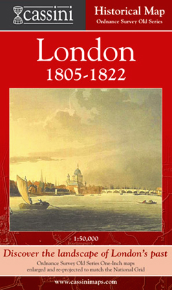
- London 1805-1822
- London in 1805-1822 in the Cassini Historical Series reproducing old Ordnance Survey mapping of England and Wales at 1:50,000. The four London maps cover roughly the area of the present day Greater London rather than following the format of rest of the series which is designed to correspond to the current Landranger maps. Mapping is identical... Leer más
Stanfords
United Kingdom
United Kingdom
- London West 1805-1920 (3-map set)
- Map No. 176, London West 1805-1920 (3-map set), in the Cassini Historical Series of old Ordnance Survey mapping of England and Wales at 1:50,000 in a format designed to offer a convenient comparison with the present day coverage from the OS, and most locations in three different editions. Old historical maps have been combined so that the sheet... Leer más

Stanfords
United Kingdom
United Kingdom
- Luxembourg North
- One of two topographic survey maps of Luxembourg at 1:50,000, with contours at 10-metres intervals and additional relief shading. An overprint highlights long-distance footpaths, including the GR5 (E-2), cycle routes, and various places of interest, including campsites. The map covers an area of approximately 53 x 43 km / 33 x 27 miles. Map... Leer más
Stanfords
United Kingdom
United Kingdom
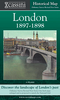
- London 1897-1898
- London in 1897-1898 in the Cassini Historical Series reproducing old Ordnance Survey mapping of England and Wales at 1:50,000. The four London maps cover roughly the area of the present day Greater London rather than following the format of rest of the series which is designed to correspond to the current Landranger maps. Mapping is identical... Leer más
Stanfords
United Kingdom
United Kingdom
- London East 1805-1922 (3-map set)
- Map No. 177, London East 1805-1922 (3-map set), in the Cassini Historical Series of old Ordnance Survey mapping of England and Wales at 1:50,000 in a format designed to offer a convenient comparison with the present day coverage from the OS, and most locations in three different editions. Old historical maps have been combined so that the sheet... Leer más

Stanfords
United Kingdom
United Kingdom
- Luxembourg South
- One of two topographic survey maps of Luxembourg at 1:50,000, with contours at 10-metres intervals and additional relief shading. An overprint highlights long-distance footpaths, including the GR5 (E-2), cycle routes, and various places of interest, including campsites. The map covers an area of approximately 53 x 43 km / 33 x 27 miles. Map... Leer más
Stanfords
United Kingdom
United Kingdom
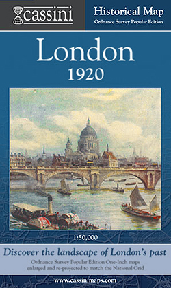
- London 1920
- London in 1920 in the Cassini Historical Series reproducing old Ordnance Survey mapping of England and Wales at 1:50,000. The four London maps cover roughly the area of the present day Greater London rather than following the format of rest of the series which is designed to correspond to the current Landranger maps. Mapping is identical to the... Leer más